
AUCTIONS (6)
 | Collection of 10 Buddhist and Bonpo ritual cards tsakli) |
 | Annamese Rosewood and Mother of Pearl Inlay Stationary Tray, 19th cent |
 | 1937 CANADA Silver One Dollar Coin VF+ |
 | Encyclopedia Britannica hello! |
SALE PRICED
 | Young People's Illustrated Bible History...1879 Engravings+Maps |
 |
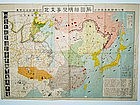
| Showa Reign - General Military Map of Troops Deployment |
Items above include suggestions and sponsored listings. |

EL-GALLERY
USD $1,500.00
USD $1,500.00
This is a Japanese military map of North Asia dated 25th/29th July, 12 Year of Showa reign. This is translated to the 12th year of Emperor Hirohito’s reign. He became emperor in 1926 and died in 1989. Add the 12 year to 1926 that translate the map dating to 1938.
This is a general Japanese military map of North Asia of the Japanese troop deployment and the armies that they are fighting against...

what pdx
$285.00
$285.00
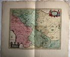
Very large engraved map of Denmark and parts of the surrounding countries important cities, mountains, rivers, and lakes. Insets of Iceland and the Faroe Islands . Designed and engraved for Thompson's "New General Atlas" July 14 1814 hand pastel colors. Great condition size 21" by 26 "
Jon Berg Fine Art and More
$245.00
$245.00
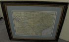
For your home or office in Texas, or elsewhere if you are homesick for the Lone Star State, a wall-ready, circa 1900 antique map of the state, by cartography publisher George F. Cram (1842-1928). Illinois-based Cram published maps in the late 19th and early 20th century in atlas form. This map came from one of those atlases. It maintains its central fold...
Jon Berg Fine Art and More
$495.00
$495.00
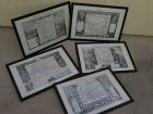
A set of five antique atlas maps, titled, "Oceanie", "Amerique Septentrionale", "Amerique Meridionale", "Europe", and "Asie", published in 1856 by A. Combette, and printed by Alfred Lemercier, Paris, after cartography by Victor Levasseur. The set is framed identically in dark, "distressed" style modern framing of good quality (each measures 15" by 22"). Maps are very clean, considering the age, with only the stray fox mark here and there...
Luis Porretta Fine Arts
$85.00
$85.00
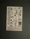
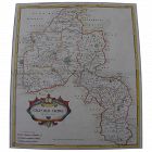
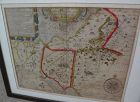
OGILVY & BOWEN c1736 Original Map of Oxfordshire Berkshire Etc.
Ogilvy & Bowen, E. :MAP: BRITANNIA DEPICTA OR OGILBY IMPROV’D; BEING A CORRECT COPY OF MR. OGILBY’S ACTUAL SURVEY OF ALL YE DIRECT & PRINCIPAL CROSSROADS IN ENGLAND AND WALES: WHEREIN ARE EXACTLY DELINEATED & ENGRAVEN, ALL YE CITIES, TOWNS, VILLAGES, CHURCHES, SEATS &C. SITU
Published in 1736, 1st Edition. Measures 8" x 5". Published by Thomas Bowle...
Jon Berg Fine Art and More
$975.00
$975.00
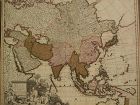
Fine antique copper engraving map of Asia from the eastern Mediterranean to the western Pacific, with hand coloring, by Dutch cartographers Gerardo and Leonardo Valk, circa 1710. The map measures 20" by 24" and is laid down to a board as is often seen. Margins are adequate...
Luis Porretta Fine Arts
$350.00
$350.00
PIETER SCHENK / VALK / JANSSEN Hand Colored superb Map Central Italy c1702
PIETER SCHENK / VALK / JANSSEN MAP OF CENTRAL ITALY
This original and very rare mapping from the 1702 publication by Schenk & Valk, the Nova totius Geographia, is in very good condition and measures 21" x 26". It shows a detail of Central Italy and has its original hand coloring still vibrant and unfaded
Jon Berg Fine Art and More
$225.00
$225.00
Antique early map of central England's Oxfordshire county, by cartographer Robert Morden, originally published in 1695. This map is nicely hand colored. It measures 17" by 15" inside the green mat and 24" by 22" framed (no glass). The mat was seemingly permanently affixed over the margins of the map by the framer, but the central portion of the map does not appear to be laid down as there is play to the surface. There is central horizontal crease and slight handling creases in the field...
Jon Berg Fine Art and More
$175.00
$175.00
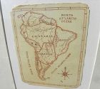
A charming completely hand-drawn map of the South American continent, likely created by a school child at a time when geography was taught to youngsters, measuring 8 1/2" by 6 1/2" (19" by 15 1/2" in black strip modern framing). The age looks to be 19th century. The creator used a red-brown ink, and pencil underlying in some places. Note the cartouche at lower right, and the quaint term "Amazonia" and "Brasil" spelling. The map has been mounted in recent times...
Jon Berg Fine Art and More
$195.00
$195.00
Early map titled "A Description of the Land of Goshen and Moses passage through the desert", 1614, by the English cartographer William Hole. Hole was active in cartography from about 1601 to about 1624. The map measures 10 3/4" by 14" inside the present mats (not examined out of the frame but would be happy to do so upon request). This is an uncommon map with a compass rose at lower right and cartouches at upper portion, the cartographer's name at lower left edge...
what pdx
$195.00
$195.00
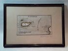
Rare antique Map of Alderney c1691 by Robert Morden with watercolor . Small scale map in nice condition framed and matted c19303s. Overall 9.75 by 6.5" map 5.25" by 3"
Jon Berg Fine Art and More
$150.00
$150.00
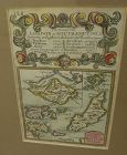
A very nice example of the 1753 map "The Smaller Islands in the British Ocean", published by T. Bowles, London, engraved by Emmanuel Owen, text by John Owen, the map featuring the Isle of Wight, Scilly Islands in the far southwest, the Channel Islands of Guernsey, Jersey, and Alderney, as well as Farne Island and Holy Island...
Luis Porretta Fine Arts
$275.00
$275.00
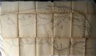
DUNLEVIE c1856 Map Counties Of Gaspe & Bonaventure Quebec Canada SCARCE! #1
Dunlevie, G. G. :MAP: MAP #3 THE COUNTIES OF GASPE AND BONAVENTURE (48" X 20")
Published in 1857, ,1st Edition. measures 51" x 48". Published in Toronto by Stewart Derbishire & George Desbarats. Published by Commissioner of Crown Lands. This scarce map is in very good condition, folded as published, printed on very thin paper so some of the folds are split, the map is a fragile one. Taken from Appendix Of The Comm...
Jon Berg Fine Art and More
$225.00
$225.00
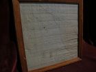
For the collector of things relating to the history of the state of Missouri, here is an early survey map drawn completely by hand, titled at top "Estate of Jos. Hickam decd. in 1848...", signed at bottom right by the surveyor, one W.W. Trent of Cooper County. Cooper County is near today's I-70, roughly between Boonville, Missouri and Columbia, Missouri. I googled these names and found considerable information on the surveyor, who apparently was in the records until at least 1889 from what I h...
Luis Porretta Fine Arts
$550.00
$550.00
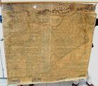
Map UNITED COUNTIES LEEDS & GRENVILLE by Walling 1861 Rare Canada Map 5ft x 5ft
MAP OF THE UNITED COUNTIES OF LEEDS AND GRENVILLE by PUTNAM AND WALLING
This is a very rare mapping seldom seen outside National Collections. It measures 5ft square and is in used condition. It is linen backed and some areas of the map are fragile and in need of some restoration. Despite its condition the rarity of this map makes this a project well worth the effort as this is a museum quality map.
Title: M...

Jon Berg Fine Art and More
$425.00
$425.00
Antique French 18th century map of the Mediterranean Sea regions and the Holy Land, titled "Carte des Regions et des Lieux....Nouveaux Testament", by noted French cartographer Rigobert Bonne (1727-1794), published Paris circa 1771. Measurements inside the mat 12 1/4" by 17 3/4" (21" by 25" as framed). Bonne was one of the premier cartographers of his day, having gained a reputation for producing accurate and practical maps. He succeeded the well-known Jacques-Nicolas Bellin as Royal Cartograp...
Luis Porretta Fine Arts
$85.00
$85.00
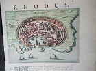
PIETER SCHENK / VALK / JANSSEN Hand Colored Map of Rhodes Greece ca1702 vgc
PIETER SCHENK / VALK / JANSSEN MAP OF RHODES
This original and very rare mapping from the 1702 publication by Schenk & Valk, the Nova totius Geographia, is in very good condition and measures 21" x 13", image size 10.5" x 8". It shows a picture of Rhodes and has its original hand coloring, still vibrant and unfaded.
David Anthony
$34.00
$34.00
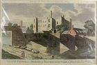
A copper engraved print from The Modern Universal British Traveler published around 1779. It is hand colored and matted.
Condition is fine to very fine. A plastic sleeve protects the print.
Dimensions (matted, inches)
Height: 11 1/2
Width: 15
Condition is fine to very fine. A plastic sleeve protects the print.
Dimensions (matted, inches)
Height: 11 1/2
Width: 15
