
AUCTIONS (6)
 | Collection of 10 Buddhist and Bonpo ritual cards tsakli) |
 | Large Imari Charger with Namban Subject Decoration |
 | ANGELICA KAUFFMANN HER LIFE AND HER WORKS BOOK Ltd Ed |
 | "Effective English": Edward Frank Allen, 1938 |
SALE PRICED
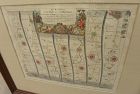
 | Young People's Illustrated Bible History...1879 Engravings+Maps |
 |
| Showa Reign - General Military Map of Troops Deployment |
Items above include suggestions and sponsored listings. |

David Anthony
$34.00
$34.00
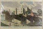
A copper engraved print from The Modern Universal British Traveler published around 1779. It is hand colored and matted.
Condition is fine to very fine. A plastic sleeve protects the print.
Dimensions (matted, inches)
Height: 11 1/2
Width: 15
Condition is fine to very fine. A plastic sleeve protects the print.
Dimensions (matted, inches)
Height: 11 1/2
Width: 15
David Anthony
$29.00
$29.00
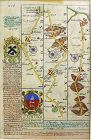
John Owen and Emanuel Bowen created innovative road maps in the early 18th C greatly aiding travelers of the day, whose publication spanned 1720-1764, titled Britannia Depicta.
This map is from pages 207/208, double-sided, and whose primary view is of Lincoln / Grimsby...
This map is from pages 207/208, double-sided, and whose primary view is of Lincoln / Grimsby...
Luis Porretta Fine Arts
$275.00
$275.00
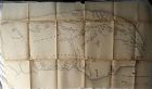
DUNLEVIE c1856 Map Counties Of Gaspe & Bonaventure Quebec Canada SCARCE! #1
Dunlevie, G. G. :MAP: MAP #3 THE COUNTIES OF GASPE AND BONAVENTURE (48" X 20")
Published in 1857, ,1st Edition. measures 51" x 48". Published in Toronto by Stewart Derbishire & George Desbarats. Published by Commissioner of Crown Lands. This scarce map is in very good condition, folded as published, printed on very thin paper so some of the folds are split, the map is a fragile one...
Luis Porretta Fine Arts
$85.00
$85.00
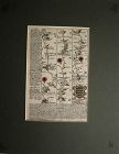
OGILVY & BOWEN c1736 Original Map of Oxfordshire Berkshire Etc.
Ogilvy & Bowen, E. :MAP: BRITANNIA DEPICTA OR OGILBY IMPROV’D; BEING A CORRECT COPY OF MR. OGILBY’S ACTUAL SURVEY OF ALL YE DIRECT & PRINCIPAL CROSSROADS IN ENGLAND AND WALES: WHEREIN ARE EXACTLY DELINEATED & ENGRAVEN, ALL YE CITIES, TOWNS, VILLAGES, CHURCHES, SEATS &C. SITU
Published in 1736, 1st Edition. Measures 8" x 5". Published by Thomas Bowle...
Luis Porretta Fine Arts
$85.00
$85.00
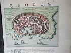
PIETER SCHENK / VALK / JANSSEN Hand Colored Map of Rhodes Greece ca1702 vgc
PIETER SCHENK / VALK / JANSSEN MAP OF RHODES
This original and very rare mapping from the 1702 publication by Schenk & Valk, the Nova totius Geographia, is in very good condition and measures 21" x 13", image size 10.5" x 8". It shows a picture of Rhodes and has its original hand coloring, still vibrant and unfaded.
Luis Porretta Fine Arts
$550.00
$550.00
Map UNITED COUNTIES LEEDS & GRENVILLE by Walling 1861 Rare Canada Map 5ft x 5ft
MAP OF THE UNITED COUNTIES OF LEEDS AND GRENVILLE by PUTNAM AND WALLING
This is a very rare mapping seldom seen outside National Collections. It measures 5ft square and is in used condition. It is linen backed and some areas of the map are fragile and in need of some restoration...
Luis Porretta Fine Arts
$350.00
$350.00
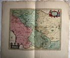
PIETER SCHENK / VALK / JANSSEN Hand Colored superb Map Central Italy c1702
PIETER SCHENK / VALK / JANSSEN MAP OF CENTRAL ITALY
This original and very rare mapping from the 1702 publication by Schenk & Valk, the Nova totius Geographia, is in very good condition and measures 21" x 26". It shows a detail of Central Italy and has its original hand coloring still vibrant and unfaded
Luis Porretta Fine Arts
$85.00
$85.00
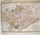
RIGOBERT BONNE 1787 Original Colored Map Germany & Region 15" x 12"
Bonne, Rigobert : MAP - CARTE DE LA PARTIE MERIODIONALE DU CERCLE DE HAUTE SAXE ( SAXONY GERMANY - ORIGINAL COLOR )
Published in 1787, Measures 15" x 12". mapped by Rigobert Bonne.
This charming map is in very good condition, full borders as published, folded as published, beautiful original hand-coloring, plate marks defined. Images available.
Jon Berg Fine Art and More
$400.00
$400.00
An example of an original 17th century copper engraving map with later hand coloring, titled "The Road from Oxford to Cambridge", from the first road atlas of England and Wales, by noted mapmaker JOHN OGILBY (1600-1676). The piece measures 14 1/2" by 17 1/2" inside the mat, 26 1/2" by 28 1/2" as framed...
Jon Berg Fine Art and More
$175.00
$175.00
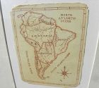
A charming completely hand-drawn map of the South American continent, likely created by a school child at a time when geography was taught to youngsters, measuring 8 1/2" by 6 1/2" (19" by 15 1/2" in black strip modern framing). The age looks to be 19th century. The creator used a red-brown ink, and pencil underlying in some places. Note the cartouche at lower right, and the quaint term "Amazonia" and "Brasil" spelling. The map has been mounted in recent times...
Jon Berg Fine Art and More
$150.00
$150.00
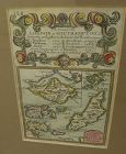
A very nice example of the 1753 map "The Smaller Islands in the British Ocean", published by T. Bowles, London, engraved by Emmanuel Owen, text by John Owen, the map featuring the Isle of Wight, Scilly Islands in the far southwest, the Channel Islands of Guernsey, Jersey, and Alderney, as well as Farne Island and Holy Island. At top is given the mile marker landmarks on the road from London to Southampton. Beautiful unusually good quality hand-coloring and condition is excellent...
Jon Berg Fine Art and More
$75.00
$75.00
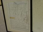
An original engraved map, titled "A Map of the Genesee Lands in the County of Ontario and State of New York according to an accurate survey which was made of the same 1790", printed in the year 1849 by engraver Richard H. Pease of Albany (1813-1869; his name at extreme bottom). The map shows Lake Ontario at top and the Finger Lakes region from Canandaigua Lake at the far right to generally the Genesee River at left...

Jon Berg Fine Art and More
$425.00
$425.00
Antique French 18th century map of the Mediterranean Sea regions and the Holy Land, titled "Carte des Regions et des Lieux....Nouveaux Testament", by noted French cartographer Rigobert Bonne (1727-1794), published Paris circa 1771. Measurements inside the mat 12 1/4" by 17 3/4" (21" by 25" as framed). Bonne was one of the premier cartographers of his day, having gained a reputation for producing accurate and practical maps...
Jon Berg Fine Art and More
$245.00
$245.00
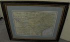
For your home or office in Texas, or elsewhere if you are homesick for the Lone Star State, a wall-ready, circa 1900 antique map of the state, by cartography publisher George F. Cram (1842-1928). Illinois-based Cram published maps in the late 19th and early 20th century in atlas form. This map came from one of those atlases...
Jon Berg Fine Art and More
$125.00
$125.00
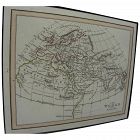
Antique small map titled "The World as known to Ptolemy", 1835, published by Joseph Thomas, London. The measurements are 5" by 6" inside the tasteful maroon map (10 1/4" by 11 1/4" framed). There is hand coloring in red outlining most of Europe. The map is very clean. Mat at lower extreme right has a bit of puckering/creasing. You could replace if so desire but most viewers would not notice this. Ptolemy was a Greco-Egyptian astronomer, geographer and mathematician who lived in Alexandria,...
Jon Berg Fine Art and More
$175.00
$175.00
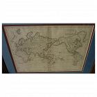
Early 19th century map of the world, in Mercator projection, the Pacific Ocean at center, titled at upper right "Mappemonde sur la Projection de Mercator", measuring 10" by 14 1/2" inside the double mats, and 16" by 21" as nicely framed. The map might date to about the 1820's. The United States is shown as "Etats Unis". There are numerous picturesque early geographic names like "Is. Sandwich/Owhyhee", "Othahiti", "Nouvelle Hollande" for Australia, The map is printed on old style paper. Othe...
Jon Berg Fine Art and More
$225.00
$225.00
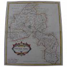
Antique early map of central England's Oxfordshire county, by cartographer Robert Morden, originally published in 1695. This map is nicely hand colored. It measures 17" by 15" inside the green mat and 24" by 22" framed (no glass). The mat was seemingly permanently affixed over the margins of the map by the framer, but the central portion of the map does not appear to be laid down as there is play to the surface. There is central horizontal crease and slight handling creases in the field. No...

Jon Berg Fine Art and More
$200.00
$200.00
An original copper plate engraved map, with hand coloring of country outlines, and also in the cartouche, titled there, at lower left, "A Map of Turky, Arabia and Persia", the first edition by Georges de l'Isle in 1701, this being the somewhat later revised 1721 edition by noted cartographer of the day John Senex (1678-ca. 1740). This map, 19" by 23" (22 1/2" by 26 1/2" as framed) was considered to be the first modern map of the Arabian Peninsula before the middle of the 18th century. The geog...
