

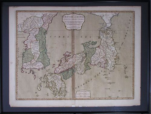

A Very Rare/Important Map of “Korea Sea” between korea and Japan
browse these categories for related items...
Directory: Antiques: Regional Art: Asian: Korean: Paintings: Pre 1800: Item # 1400674
Directory: Antiques: Regional Art: Asian: Korean: Paintings: Pre 1800: Item # 1400674
Please refer to our stock # 1714 when inquiring.
Harubang Antiques
View Seller Profile
3712 - 80th Avenue SE
Mercer Island, Washington 98040
(206) 236-2374
Guest Book
View Seller Profile
3712 - 80th Avenue SE
Mercer Island, Washington 98040
(206) 236-2374
Guest Book
SOLD
A Very Rare/Important Map of Straits between Korea and Japan “Korea Sea” Named-late 18th C.: 1794 printed by Laurie & Whittle,
The map is one of very important documents of evodence/written as “Corea (Korea) Sea”
between Korea and Japan in 1794 as “Corea Sea” in the international map, but by now,
the most of the world maps and the most influential world news papers or the public
medias are printing/writing it as “Japan Sea”(Sea of Japan).
So, this is one of the very important documents of the evidence that the current disputed its name between Korea and Japan used as “Korea Sea” long time ago, at least since the
middle of the 18th century. From now the name of the Straits between Korea and Japan must be named “Korea (Corea) Sea” instead of “Japan Sea”.
It’s in good condition as a 18th century Map with 2 small hairline creases, it measurea 21” c 28” (53cm x 71cm).
*** Reference: https://news.joins.com/article/23437823?cloc=joongang|home|newslist1.
“Please copy and paste it” 2019.04.11 15:26


