
AUCTIONS (6)
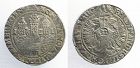
 | Large Imari Charger with Namban Subject Decoration |
 | Collection of 10 Buddhist and Bonpo ritual cards tsakli) |
 | The World of Atget ~ Berenice Abbott~ 1964 |
 | Encyclopedia Britannica hello! |
SALE PRICED
 | Young People's Illustrated Bible History...1879 Engravings+Maps |
 Traditional Collectibles (807)


Jon Berg Fine Art and More
$195.00
$195.00
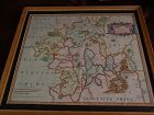
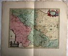
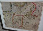
This is a very detailed map of Worcestershire in western England, first engraved by noted London map maker Robert Morden in 1695 for Camden's Britannia, and issued in several later editions in the early years of the 18th century. The map measures 14 1/4" by 16 5/8" inside the mat (17" by 19" as framed). Like most of its type it has been hand colored at a later date...
SwisSiam-Arts-Antiques-Gems
USD $475.00
USD $475.00
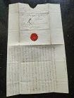
A very rare Original Letter written in black ink and bearing the Seal of the late Duchess of Richelieu (France) to Monsieur de Sinner, Berne, Switzerland, DATED 1797.
Size open letter: 18 cm. x 15 cm.
French Transcript available upon request.
Price: US$ 475
Luis Porretta Fine Arts
$85.00
$85.00
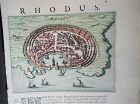
PIETER SCHENK / VALK / JANSSEN Hand Colored Map of Rhodes Greece ca1702 vgc
PIETER SCHENK / VALK / JANSSEN MAP OF RHODES
This original and very rare mapping from the 1702 publication by Schenk & Valk, the Nova totius Geographia, is in very good condition and measures 21" x 13", image size 10.5" x 8". It shows a picture of Rhodes and has its original hand coloring, still vibrant and unfaded.
David Anthony
$34.00
$34.00
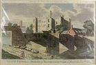
A copper engraved print from The Modern Universal British Traveler published around 1779. It is hand colored and matted.
Condition is fine to very fine. A plastic sleeve protects the print.
Dimensions (matted, inches)
Height: 11 1/2
Width: 15
Condition is fine to very fine. A plastic sleeve protects the print.
Dimensions (matted, inches)
Height: 11 1/2
Width: 15
Luis Porretta Fine Arts
$350.00
$350.00
PIETER SCHENK / VALK / JANSSEN Hand Colored superb Map Central Italy c1702
PIETER SCHENK / VALK / JANSSEN MAP OF CENTRAL ITALY
This original and very rare mapping from the 1702 publication by Schenk & Valk, the Nova totius Geographia, is in very good condition and measures 21" x 26". It shows a detail of Central Italy and has its original hand coloring still vibrant and unfaded
All Items : Traditional Collectibles : Ephemera : Autographs : Historical : Pre 1800
item #1480374
(stock #4118)
Watch Company
$449.00
$449.00
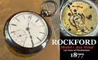
ROCKFORD WATCH CO.
Rockford, Illinois
1873 – 1915
The Rockford Watch Company’s equipment was bought from the Cornell Watch Col, and two of Cornell’s employees, C.W. Parker and P.H. Wheeler, went to work for Rockford. The factory was located 93 miles from Chicago on the Rock Rover. The first watch was placed on the market on May1, 1878. They were key wind, 18 size, full plate expansion balance and dials made by outside contract...
David Anthony
$175.00
$175.00
Hardcover. Condition: Good. 2nd Edition. Bound in polished leather, printed on laid paper, gilt tooling on spine, all leather spine labels intact, all covers attached, binding and hinges secure. Previous ownership: armorial bookplate for Thomas Taylor, County Devon parish Denbury...
Jon Berg Fine Art and More
$1,100.00
$1,100.00
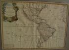
Very nicely presented, wall-ready antique map centered on the Americas, 1784, by Paris-based late 18th century cartographer Jean Janvier. The map, 19" by 25 3/4"inside the mat and 30 3/4" by 36 3/4" in new black ornate frame, is generally in fresh, clean condition, with center fold and some unevenness of the paper, which photographs as shadows or brown areas...
Jon Berg Fine Art and More
$975.00
$975.00
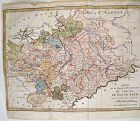
Fine antique copper engraving map of Asia from the eastern Mediterranean to the western Pacific, with hand coloring, by Dutch cartographers Gerardo and Leonardo Valk, circa 1710. The map measures 20" by 24" and is laid down to a board as is often seen. Margins are adequate...
David Anthony
$29.00
$29.00
John Owen and Emanuel Bowen created innovative road maps in the early 18th C greatly aiding travelers of the day, whose publication spanned 1720-1764, titled Britannia Depicta.
This map is from pages 207/208, double-sided, and whose primary view is of Lincoln / Grimsby...
This map is from pages 207/208, double-sided, and whose primary view is of Lincoln / Grimsby...
Luis Porretta Fine Arts
$85.00
$85.00
RIGOBERT BONNE 1787 Original Colored Map Germany & Region 15" x 12"
Bonne, Rigobert : MAP - CARTE DE LA PARTIE MERIODIONALE DU CERCLE DE HAUTE SAXE ( SAXONY GERMANY - ORIGINAL COLOR )
Published in 1787, Measures 15" x 12". mapped by Rigobert Bonne.
This charming map is in very good condition, full borders as published, folded as published, beautiful original hand-coloring, plate marks defined. Images available.

Watch Company
$750.00
$750.00
NEW YORK WATCH Co.
Providence, Rhode Island
1866-1875
In 1866 the name of this company was changed from the Mozart Watch Co. to the New York Watch Co. and was in Rhode Island. Before any watches were sold, they moved to Springfield, Mass. In 1867. A factory was built there, but only about 100 watches were produced before a fire occurred on April 23, 1870. Shortly after the fire, in 1870, a newly designed watch was introduced. The New York Watch Co...
In 1866 the name of this company was changed from the Mozart Watch Co. to the New York Watch Co. and was in Rhode Island. Before any watches were sold, they moved to Springfield, Mass. In 1867. A factory was built there, but only about 100 watches were produced before a fire occurred on April 23, 1870. Shortly after the fire, in 1870, a newly designed watch was introduced. The New York Watch Co...
Luis Porretta Fine Arts
$85.00
$85.00
OGILVY & BOWEN c1736 Original Map of Oxfordshire Berkshire Etc.
Ogilvy & Bowen, E. :MAP: BRITANNIA DEPICTA OR OGILBY IMPROV’D; BEING A CORRECT COPY OF MR. OGILBY’S ACTUAL SURVEY OF ALL YE DIRECT & PRINCIPAL CROSSROADS IN ENGLAND AND WALES: WHEREIN ARE EXACTLY DELINEATED & ENGRAVEN, ALL YE CITIES, TOWNS, VILLAGES, CHURCHES, SEATS &C. SITU
Published in 1736, 1st Edition. Measures 8" x 5". Published by Thomas Bowle...

Jon Berg Fine Art and More
$200.00
$200.00
An original copper plate engraved map, with hand coloring of country outlines, and also in the cartouche, titled there, at lower left, "A Map of Turky, Arabia and Persia", the first edition by Georges de l'Isle in 1701, this being the somewhat later revised 1721 edition by noted cartographer of the day John Senex (1678-ca. 1740). This map, 19" by 23" (22 1/2" by 26 1/2" as framed) was considered to be the first modern map of the Arabian Peninsula before the middle of the 18th century...
Jon Berg Fine Art and More
$150.00
$150.00
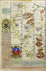
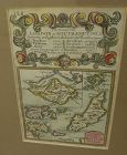
A very nice example of the 1753 map "The Smaller Islands in the British Ocean", published by T. Bowles, London, engraved by Emmanuel Owen, text by John Owen, the map featuring the Isle of Wight, Scilly Islands in the far southwest, the Channel Islands of Guernsey, Jersey, and Alderney, as well as Farne Island and Holy Island. At top is given the mile marker landmarks on the road from London to Southampton...
Jon Berg Fine Art and More
$700.00
$700.00
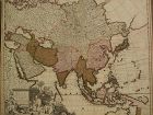
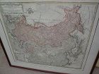
Original map printed in the year 1739 in Nuremberg, Germany, titled in cartouche at upper left "Imperii Russici et Tartariae Universiae", published by the heirs of important cartographer Johann Baptiste Homanns. The attractive map shows most of Asia from the Baltic Sea to the Pacific Ocean, and from the Arctic Ocean to India, including the Korean peninsula, Japan, and Taiwan. The map measures 20" by 22 1/2" inside the mat and 25 1/2" by 28" as framed. Condition is excellent. I see at least o...
STUDIO ANTIQUES & FINE ART, INC.
$450.00
$450.00
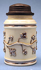
A Rare Stoneware Wine Flask (called a “Schraubflasche” in German), cylindrical with a pewter screw top, sloped shoulder and white glazed body with applied silvered decoration of a scrolling branch with leaves and berries. Silvered underglazed mark on base.
Probably German, 18th Century (chip to base)
Height: 5.25"
Diameter: 3"
Luis Porretta Fine Arts
$275.00
$275.00
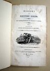
THOMAS BEWICK c1797 History British Birds 1st Edition Vol. 1 SCARCE!
Bewick, Thomas : A HISTORY OF BRITISH BIRDS THE FIGURES ENGRAVED ON WOOD BY T. BEWICK. VOL. 1 CONTAINING THE HISTORY AND DESCRIPTION OF LAND BIRDS
Published in 1797, 1st Edition. Measures 8" x 6.5". Published by Sol. Hodgson, for Belby & Bewick.
Beautifully rebound in tan half calf, maroon Morocco label with gilt titles, marbled boards, 117 figures of birds of which 44 have been hand colored, a lovely clean, tight cop...
Luis Porretta Fine Arts
$550.00
$550.00
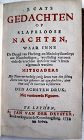
JAN VAN DER DESYATER c1732 First Edition Thoughts On Sleepless Nights Rare!
Desyster, Jan Van Der :GEDACHTEN OP SLAPELOOSE NACHTEN WAAR INNE DE DEUGD VAN-HERBERG-EN MEDEDEYLFAAMHEYT AAN NOOTDRUHSTIGEN ETC. ETC. (THOUGHTS ON SLEEPLESS NIGHTS)
Published in Amsterdam in 1732, 1st Edition. Measures 7" x 4.25". Published by Koornbrugsteeg. Bound in brown half calf with grained papered boards, edges a little rubbed, six raised panels with gilt floral decoration within panels, lacks label, cont...
All Items : Traditional Collectibles : Wine and Related : Coasters : Pre 1800
item #1475935
(stock #4107)

Watch Company
$750.00
$750.00
AMERICAN WATCH CO.
1859 – 1873
Boston, Mass.
Commonly referred to as “The Mother of all American Watch Companies”, this manufacturer was a international pioneer in watch production and accuracy. They were the first to gain independence from European watch providers in the New World. But more than that, they sought to provide a more accurate watch at a affordable price to the American Citizen. After beginning activity in Boston by the Boston Watch Co. 1853 – 1859, In January 1...
All Items : Traditional Collectibles : Numismatics : Coins : European : Pre 1800
item #1433830
(stock #6596)

Abhaya Asian Antiques
$120.00
$120.00
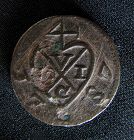
Beautiful commemorative medal, designed by Martin Holtzhey for William IV, Prince of Orange (1711-1751) and Princess Anne (1709-1759), celebrating the birth of Prince William V of Orange, Silver Medalet, 1748, , conjoined busts right, rev angel with infant child, 24mm. Free Shipping.
All Items : Traditional Collectibles : Numismatics : Coins : Asian : Pre 1800
item #1446775
(stock #7042)
Abhaya Asian Antiques
$100.00
$100.00
100.00
Rare 1787 British East India Penang half cent coin, Balemark series. D: 17mm, weight 4 grams. Free shipping.
All Items : Traditional Collectibles : Numismatics : Coins : Asian : Pre 1800
item #1451835
(stock #7145)
Abhaya Asian Antiques
$110.00
$110.00
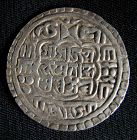
Silver Nepal, Mohar Bhupatindra Malla, mohar circa 1696-1722CE. D: 28mm, 6grams. VG. Free shipping.
All Items : Traditional Collectibles : Numismatics : Coins : Asian : Pre 1800
item #1451900
(stock #7146)
Abhaya Asian Antiques
$110.00
$110.00
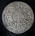
Silver Nepali mohar, from the reign of Prithvi Narayan Shah circa 1768-1775CE. VG. D: 29mm, 6 grams.
Jon Berg Fine Art and More
$300.00
$300.00
Antique book, volume 3 (originally of a set of 3), printed in Geneva, "Histoire de Geneve", originally by Jacob Spon (1647-1685), this a later improved edition published by Fabri & Barrillot in the year 1730. Small size, 6 1/2" by 4", 672 pages. No maps or imagery. The cover is worn leather (spine) and patterned paperboard. Condition is good overall; spine shows heavy wear, cover has wear; pages are not torn, and are generally clean; evenly age-toned/browned consistent with being 300 years ...
Luis Porretta Fine Arts
$1,750.00
$1,750.00
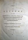
WILLIAM ROY Rare Navigation Book c1797 Trigonometry Between Paris & Greenwich
Roy, Major General William :AN ACCOUNT OF THE TRIGONOMETRICAL OPERATION WHEREBY THE DISTANCE BETWEEN THE MERIDIANS OF THE OBSERVATORIES OF GREENWICH AND PARIS HAS BEEN DETERMINED
Published in 1790, ,1st Edition. Measures 10.5" x 9". Publishged by the Philosophical Transactions of the Royal Society of London.
Bound in full brown calf, edges rubbed, hinges reinforced with black cloth tape, marbled boards, bookpla...
All Items : Traditional Collectibles : Numismatics : Coins : European : Pre 1700
item #1465083
(stock #7131)
Abhaya Asian Antiques
$130.00
$130.00
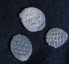
Three historical coins from the old Russian Empire. 1) Ivan the Terrible- silver kopek, 1553-1589, Moscow mint, W: 15mm. 2) Boris Godunov- silver kopek, 1598-1605, Moscow mint, W: 13mm. 3) Peter the Great silver kopek, 1689-1725, W: 12mm. Free shipping.
Senatus Consulto
$950.00
$950.00
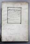
A very rare and complete antique license document, Spanish and signed by the Spanish King Philip the IV (Ruler 1621-1665).
The document is binded with 8/16 pages with 14 decorated or with signatures (let us know if you like to receive pictures of all pages by e-mail). We would like to stress the importance of the document which signed by no less than 15-20 signatures, besides the signature of Philip himself. These co-signers could well be important members of his cabinet or high leve...
The document is binded with 8/16 pages with 14 decorated or with signatures (let us know if you like to receive pictures of all pages by e-mail). We would like to stress the importance of the document which signed by no less than 15-20 signatures, besides the signature of Philip himself. These co-signers could well be important members of his cabinet or high leve...
All Items : Traditional Collectibles : Numismatics : Coins : European : Pre 1700
item #1466089
(stock #7171)
Abhaya Asian Antiques
$150.00
$150.00
XF silver coin from Hungary under Ferdinand I - Holy Roman Emperor. 1537CE. Depicting Madonna and child and coat of arms. Diameter: 15mm and 0.6gram. Free shipping.
Senatus Consulto
$495.00
$495.00
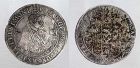
A beautiful and very sharp German silver thaler, from Saxony or Sachsen 1638.
Dav 7601 (scarce in this quality!)
Condition: Finely toned, EF, flan flaw at 10, uncleaned reverse.
Weight: 28,46 grams
Ex. Danish Private Collection
Dav 7601 (scarce in this quality!)
Condition: Finely toned, EF, flan flaw at 10, uncleaned reverse.
Weight: 28,46 grams
Ex. Danish Private Collection
Luis Porretta Fine Arts
$3,500.00
$3,500.00
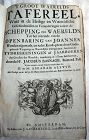
JACOBUS BASAGNE c1710 Theological History Numerous Engravings by De Hooghe Rare!
Basnage, Jacobus (Jacques). (1653-1723) :T GROOT WAERELDS TAFEREEL, WAAR IN DE HEILIGE EN WAERELDSCHE GESCHIEDENISSEN EN VERANDERINGEN ZEDERT DE SCHEPPING DES WAERELDS, TOT HET UITEINDE VAN DE OPENBARING VAN JOANNES, WORDEN AFGEMAALT, EN IEDER KONST-PRENT DOOR GODS-GELEERDE WYSGEERIGE EN WAERELD
Published in Amsterdam in 1710, ,1st Edition. ,14" x 9.5". Published by J. Lindenberg. Bound in tan half calf with...
Luis Porretta Fine Arts
$750.00
$750.00
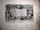
OFFER VAN ABRAHAM Book Of Genesis in Engravings c1700 Amsterdam Very rare!
Abraham, Offer Van :LIBER GENESIS - 52 ENGRAVINGS
Published in Amsterdam c1700, Measures 7.5" x 6". Published by Isaac Greve.
Bound in c18th buff hand decorated paper wraps. Between the wraps are 52 (ex 60? ? ) engravings illustrating scenes from the Book Of Genesis. The engravings measure 82mm x 125mm (4.5" x 3") picture size, overall size 7.5" x 6". A very scarce publication only represented in the British Muse...
Senatus Consulto
$465.00
$465.00
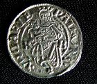
HAMBURG, REICHSSTADT - FERDINAND II, 1619-1637 - Reichstaler.
obv. Castle with three towers and open doors and risen porticullis (arms of Hamburg) with date (1-6-2-1) split between towers within circle of beads. In outer circle the legend MONETA•NOVA•CIVITATIS•HAMBURGENSIS• and fist with tinhook
rev. Crown above double-headed eagle with value in shillings (32) on breast within circle of beads. In outer circle the legend FERDINANDUS•II•D:G:ROMA:IMP:S:A:
Jon Berg Fine Art and More
$195.00
$195.00
Early map titled "A Description of the Land of Goshen and Moses passage through the desert", 1614, by the English cartographer William Hole. Hole was active in cartography from about 1601 to about 1624. The map measures 10 3/4" by 14" inside the present mats (not examined out of the frame but would be happy to do so upon request). This is an uncommon map with a compass rose at lower right and cartouches at upper portion, the cartographer's name at lower left edge. There is probably much late...
what pdx
$195.00
$195.00
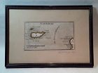
Rare antique Map of Alderney c1691 by Robert Morden with watercolor . Small scale map in nice condition framed and matted c19303s. Overall 9.75 by 6.5" map 5.25" by 3"
Jon Berg Fine Art and More
$325.00
$325.00
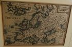
This is a miniature map, 3 3/8" by 4 7/8" inside the mat, titled at upper right "EUROPA", and bearing at lower right the name of the engraver cartographer, Pieter van den Keere (Petrus Kaerius). The entire sweep of Europe is shown, from Greenland and Atlantic islands on the west to as far east as Turkey, the Middle East, and "Tartaria". Kaerius (circa 1571-1646) was born in the Low Countries and fled to London due to religious persecution, in 1584. There he became established in engraving map...