

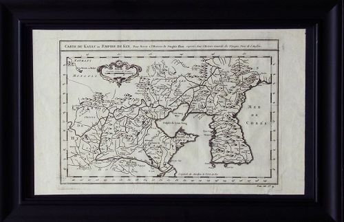
Fine a Map of Korea with Sea of Corea (Mer De Corea-大韓海峽)-18th C
browse these categories for related items...
Directory: Antiques: Regional Art: Asian: Korean: Paintings: Pre 1900: Item # 1459979
Directory: Antiques: Regional Art: Asian: Korean: Paintings: Pre 1900: Item # 1459979
Please refer to our stock # 1783 when inquiring.
Harubang Antiques
View Seller Profile
3712 - 80th Avenue SE
Mercer Island, Washington 98040
(206) 236-2374
Guest Book
View Seller Profile
3712 - 80th Avenue SE
Mercer Island, Washington 98040
(206) 236-2374
Guest Book
$1,300
A Very Fine a Map of Korea with Sea of Corea (Mer De Corea-大韓海峽)-18th C.: 1746 Published.
It's in good condition, framed, it measures 39cm x 24cm image only.
This fine engraving map is from Antoine-Francois Prevost d'Exiles's Histoire Générale des Voyages, ou nouvelle collection de toutes les relations de voyages par mer et par terre, qui ont été publiées jusqu'à present dans les différentes langues de toutes les nations connues. The work was published by Chez Didot in Paris in 1746. The plates and maps were by Cochin fils, Tardieu, B. L. Prevost and others.
***It was an expansive work that referenced China, the East Indies, Asia, the Americas, early Austrlian voyages, New Guinea, Palau Islands, Africa, and voyages in the Pacific including those of Magellan, Schouten, and Le Maire, Drake, Sarmiento, Cavendish, Spilbergen, Narborough, Rogers, Cowley, Frazier, and Anson. The work included particularly full accounts are given of the Dutch and French voyages to the East Indies, voyages to China, and the British East India Company's voyages to India and Ceylon. (Hill).
Artist or Maker: Antoine-Francois Prevost d'Exiles, Medium, Engraving,
Literature: Histoire Generale des Voyages, ou Nouvelle Collection de Toutes les Relations de Voyages, par Mer et par Terre…


