

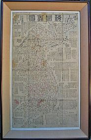

Large/Old Map of Korean Peninsula “Hae Joa Jun Do"
browse these categories for related items...
Directory: Antiques: Regional Art: Asian: Korean: Paintings: Pre 1900: Item # 972926
Directory: Antiques: Regional Art: Asian: Korean: Paintings: Pre 1900: Item # 972926
Please refer to our stock # 654 when inquiring.
Harubang Antiques
View Seller Profile
3712 - 80th Avenue SE
Mercer Island, Washington 98040
(206) 236-2374
Guest Book
View Seller Profile
3712 - 80th Avenue SE
Mercer Island, Washington 98040
(206) 236-2374
Guest Book
SOLD
A Large and Old Map of Korean Peninsula “Hae Joa Jun Do”:
Korea, Choson Dynasty, 19th Century
This old and large map of Korean peninsula p made in ink and color (blue and red faded)
on Korean rice paper, togther with printed list of distance from various places to the capital,
a milage chart of the distandes between cities, and other milage charts, described of all cities
and histories of Korean peninsula geological events by regions, and other detailed descriptions.
This is an amaging historical map of Korea Peninsula with all details of need in that time.
It is in very good condition except minor damages on upper corner and some stains.
Measurements; 102cm x 58.5cm map painting only, framed with plexi glass (if necessary, it can be removed from a frame). This map is one of Korean maps first made by Kim Chung-ho (Please see photos and compare this map with Kim’s map illustrated in the book, and my Korean map’s condition is much better than Kim’s map illustrated in a book—Please read a reference below).
Reference: A 100% identical Korean peninsula map see Korean Folk Artt and Craft, by Adward B. Adams, Seoul International Publishing House, 1983, P88 (this map illustrated in this book collected by a Museum in Korea), and described by auther “This map was made by a famous Korean geographer, Kim Chung-Ho, in the 19th century. The map was produced in a scale of 1 to 900,000 through actual survey. It was first made by woodblock print, and then color was painted over the map, which shows realictic mountain ridges. In the black space, a brief summery of Korean natural, historical and geographical charactericts is written. Almost close to today’s maps of Korea showint the land shape accurately, it is an excellent example of demonstrating the cartographic skills that had developed in map making during the Choson dynasty (please see photo).”

