

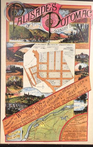
“Palisades Of The Potomac” Map Circa 1900 36x24”
browse these categories for related items...
Directory: Fine Art: Drawings: Contemporary: Item # 1454352
Directory: Fine Art: Drawings: Contemporary: Item # 1454352
Please refer to our stock # 571 when inquiring.
L'Enfant Gallery
View Seller Profile
1442 Wisconsin Ave, N.W.
Washington, DC 20007
202-625-2873
Guest Book
View Seller Profile
1442 Wisconsin Ave, N.W.
Washington, DC 20007
202-625-2873
Guest Book
$1,200.00


A beautiful 20th Century reproduction of a circa 1900 map of Washington DC neighborhood of Palisades. In June 1909, the Potomac Heights Land Co. (based in North Carolina) acquired 75 acres (300,000 m2) previously known as the Athletic Park tract at the reported cost of $1000 an acre. The tract extends parallel with and between Conduit Road and the Potomac. It is divided by the Washington Railway and Electric Company, which ran from Georgetown to Glen Echo for a 5 cent fare. There were 800 lots at $450–$500 per lot and no home was to be erected at less than $2500.
The Palisades is part of Advisory Neighborhood Commission 3D in Ward 3, the far northwest corner of the Northwest Quadrant just north of Georgetown. The current Palisades Citizens Association (PCA) was started as the Conduit Road Citizens Association in 1916.
The old MacArthur Theater, now used as a CVS/pharmacy, in the Palisades
The Palisades is one of the lesser-known neighborhoods in Washington, with a mixture of detached houses, townhouses and apartments. The homes along the bluff on Potomac Avenue offer a broad view of the Potomac River and the Virginia riverfront, with often impressive sunset views.
Since 1928, the Palisades has been served by the Francis Scott Key Elementary School, which is part of the DC Public Schools.


