
FEATURED ITEMS
 | Rolex 16mm Yellow Plate Buckle 20mm Forest Green Genuine Crocodile |
 | 1937 CANADA Silver One Dollar Coin VF+ |
SALE PRICED
 | Young People's Illustrated Bible History...1879 Engravings+Maps |
 |
 |
| Antique circa 1710 map of Asia by cartographers Gerardo and Leonardo Valk | Showa Reign - General Military Map of Troops Deployment |
Items above include suggestions and sponsored listings. |
|

what pdx
$195.00
$195.00
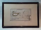
Rare antique Map of Alderney c1691 by Robert Morden with watercolor . Small scale map in nice condition framed and matted c19303s. Overall 9.75 by 6.5" map 5.25" by 3"
Jon Berg Fine Art and More
$175.00
$175.00
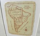
A charming completely hand-drawn map of the South American continent, likely created by a school child at a time when geography was taught to youngsters, measuring 8 1/2" by 6 1/2" (19" by 15 1/2" in black strip modern framing). The age looks to be 19th century. The creator used a red-brown ink, and pencil underlying in some places. Note the cartouche at lower right, and the quaint term "Amazonia" and "Brasil" spelling. The map has been mounted in recent times...
Jon Berg Fine Art and More
$175.00
$175.00
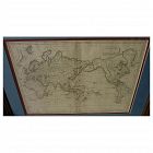
Early 19th century map of the world, in Mercator projection, the Pacific Ocean at center, titled at upper right "Mappemonde sur la Projection de Mercator", measuring 10" by 14 1/2" inside the double mats, and 16" by 21" as nicely framed. The map might date to about the 1820's. The United States is shown as "Etats Unis". There are numerous picturesque early geographic names like "Is. Sandwich/Owhyhee", "Othahiti", "Nouvelle Hollande" for Australia, The map is printed on old style paper...
Jon Berg Fine Art and More
$150.00
$150.00
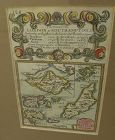
A very nice example of the 1753 map "The Smaller Islands in the British Ocean", published by T. Bowles, London, engraved by Emmanuel Owen, text by John Owen, the map featuring the Isle of Wight, Scilly Islands in the far southwest, the Channel Islands of Guernsey, Jersey, and Alderney, as well as Farne Island and Holy Island. At top is given the mile marker landmarks on the road from London to Southampton. Beautiful unusually good quality hand-coloring and condition is excellent...
Jon Berg Fine Art and More
$125.00
$125.00
Antique small map titled "The World as known to Ptolemy", 1835, published by Joseph Thomas, London. The measurements are 5" by 6" inside the tasteful maroon map (10 1/4" by 11 1/4" framed). There is hand coloring in red outlining most of Europe. The map is very clean. Mat at lower extreme right has a bit of puckering/creasing. You could replace if so desire but most viewers would not notice this...
Hundred and One Antiques
$75.00
$75.00
Published as the Act directs by Brightly & Kinnersley Bungay, May 1st 1807.
Copper engraved map with contemporary outline hand color.
CONDITION: in good condition.
MEASUEMENTS: 10 ¼ x 8 1/8 inches
Copper engraved map with contemporary outline hand color.
CONDITION: in good condition.
MEASUEMENTS: 10 ¼ x 8 1/8 inches
ALL ITEMS ARE GUARANTEED TO BE AUTHENTIC ANTIQUES, AND NOT REPRODUCTIONS.
ALL OUR ARTIFACTS ARE ACCOMPANIED BY A CERTIFICATE OF AUTHENTICITY.
Jon Berg Fine Art and More
$75.00
$75.00
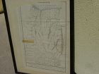
An original engraved map, titled "A Map of the Genesee Lands in the County of Ontario and State of New York according to an accurate survey which was made of the same 1790", printed in the year 1849 by engraver Richard H. Pease of Albany (1813-1869; his name at extreme bottom). The map shows Lake Ontario at top and the Finger Lakes region from Canandaigua Lake at the far right to generally the Genesee River at left...
Hundred and One Antiques
$75.00
$75.00
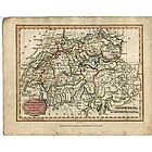
“England and Wales from the best Authorities" published as the act by Brightly & Kinnersley Bungay, February 10th, 1807. In upper corner references to the Counties. Copper engraved map with contemporary outline hand color.
Engraved by J. Barlow.
CONDITION: Good condition.
MEASUREMENTS: Size 10 ¼ x 8 1/8 inches
CONDITION: Good condition.
MEASUREMENTS: Size 10 ¼ x 8 1/8 inches
ALL OUR ARTIFACTS ARE ACCOMPANIED BY A CERTIFICATION OF AUTHENTICITY
WE SHIP INTERNATIONALLY
Hundred and One Antiques
$75.00
$75.00
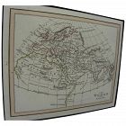
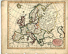
"Europe from the Best Authorities" published as the Act directs by C. Brightly & E. Kinnersley Bungay Suffolk August 24th, 1815. Copper engraved map with original
MEASUREMENTS: 10 ½ x 8 ¼ inches
MEASUREMENTS: 10 ½ x 8 ¼ inches
ALL OUR ARTIFACTS ARE ACCOMPANIED BY A CERTIFICATION OF AUTHENTICITY
WE SHIP INTERNATIONALLY
David Anthony
$34.00
$34.00
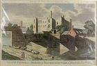
A copper engraved print from The Modern Universal British Traveler published around 1779. It is hand colored and matted.
Condition is fine to very fine. A plastic sleeve protects the print.
Dimensions (matted, inches)
Height: 11 1/2
Width: 15
Condition is fine to very fine. A plastic sleeve protects the print.
Dimensions (matted, inches)
Height: 11 1/2
Width: 15
David Anthony
$29.00
$29.00
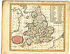
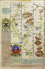
John Owen and Emanuel Bowen created innovative road maps in the early 18th C greatly aiding travelers of the day, whose publication spanned 1720-1764, titled Britannia Depicta.
This map is from pages 207/208, double-sided, and whose primary view is of Lincoln / Grimsby...
This map is from pages 207/208, double-sided, and whose primary view is of Lincoln / Grimsby...
