
AUCTIONS (2)
 | Fine quality Ohi Ware Macha bowl by Yoshio Iwamura |
 | Antique Tibetan painted wood image of Green Tara Bodhisattva |
 | HOROLOGY 38mm Triple Date Moon Phase Valjou English |
 | 1st ED ~ Inspiring Reform ~Boston's Arts & Crafts Movement HC/DJ |
SALE PRICED
 | Young People's Illustrated Bible History...1879 Engravings+Maps |
 |
 |
| Showa Reign - General Military Map of Troops Deployment | Large nicely framed 1784 antique map "L'Amerique divisee en Ses principaux Etats" |
Items above include suggestions and sponsored listings. |
|

Jon Berg Fine Art and More
$75.00
$75.00
An original engraved map, titled "A Map of the Genesee Lands in the County of Ontario and State of New York according to an accurate survey which was made of the same 1790", printed in the year 1849 by engraver Richard H. Pease of Albany (1813-1869; his name at extreme bottom). The map shows Lake Ontario at top and the Finger Lakes region from Canandaigua Lake at the far right to generally the Genesee River at left...

Jon Berg Fine Art and More
$425.00
$425.00
Antique French 18th century map of the Mediterranean Sea regions and the Holy Land, titled "Carte des Regions et des Lieux....Nouveaux Testament", by noted French cartographer Rigobert Bonne (1727-1794), published Paris circa 1771. Measurements inside the mat 12 1/4" by 17 3/4" (21" by 25" as framed). Bonne was one of the premier cartographers of his day, having gained a reputation for producing accurate and practical maps...
David Anthony
$34.00
$34.00
A copper engraved print from The Modern Universal British Traveler published around 1779. It is hand colored and matted.
Condition is fine to very fine. A plastic sleeve protects the print.
Dimensions (matted, inches)
Height: 11 1/2
Width: 15
Condition is fine to very fine. A plastic sleeve protects the print.
Dimensions (matted, inches)
Height: 11 1/2
Width: 15
Jon Berg Fine Art and More
$225.00
$225.00
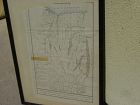
For the collector of things relating to the history of the state of Missouri, here is an early survey map drawn completely by hand, titled at top "Estate of Jos. Hickam decd. in 1848...", signed at bottom right by the surveyor, one W.W. Trent of Cooper County. Cooper County is near today's I-70, roughly between Boonville, Missouri and Columbia, Missouri...
Hundred and One Antiques
$75.00
$75.00
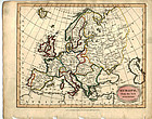
"Europe from the Best Authorities" published as the Act directs by C. Brightly & E. Kinnersley Bungay Suffolk August 24th, 1815. Copper engraved map with original
MEASUREMENTS: 10 ½ x 8 ¼ inches
MEASUREMENTS: 10 ½ x 8 ¼ inches
ALL OUR ARTIFACTS ARE ACCOMPANIED BY A CERTIFICATION OF AUTHENTICITY
WE SHIP INTERNATIONALLY
Jon Berg Fine Art and More
$975.00
$975.00
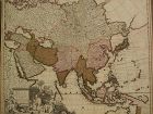
Fine antique copper engraving map of Asia from the eastern Mediterranean to the western Pacific, with hand coloring, by Dutch cartographers Gerardo and Leonardo Valk, circa 1710. The map measures 20" by 24" and is laid down to a board as is often seen. Margins are adequate...
Jon Berg Fine Art and More
$795.00
$795.00
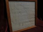
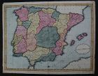
This is a HAND DRAWN map, not a print of any kind, probably crafted, with great care, by an American school child, who did not add his or her name, but did date this in the year 1809. The title is "A Map of SPAIN & PORTUGAL from the best Authorities". Unframed, it measures 16 1/8" by 20 3/4". The work contains amazing, loving detail, with towns, rivers, provinces, even mountain ranges, drawn in. The provinces are outlined and colored, creating a patchwork effect that adds to the appeal...
Jon Berg Fine Art and More
$400.00
$400.00
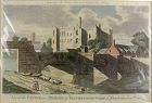
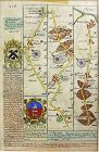
An example of an original 17th century copper engraving map with later hand coloring, titled "The Road from Oxford to Cambridge", from the first road atlas of England and Wales, by noted mapmaker JOHN OGILBY (1600-1676). The piece measures 14 1/2" by 17 1/2" inside the mat, 26 1/2" by 28 1/2" as framed...
Jon Berg Fine Art and More
$125.00
$125.00
Antique small map titled "The World as known to Ptolemy", 1835, published by Joseph Thomas, London. The measurements are 5" by 6" inside the tasteful maroon map (10 1/4" by 11 1/4" framed). There is hand coloring in red outlining most of Europe. The map is very clean. Mat at lower extreme right has a bit of puckering/creasing. You could replace if so desire but most viewers would not notice this...
Jon Berg Fine Art and More
$150.00
$150.00
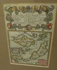
A very nice example of the 1753 map "The Smaller Islands in the British Ocean", published by T. Bowles, London, engraved by Emmanuel Owen, text by John Owen, the map featuring the Isle of Wight, Scilly Islands in the far southwest, the Channel Islands of Guernsey, Jersey, and Alderney, as well as Farne Island and Holy Island. At top is given the mile marker landmarks on the road from London to Southampton. Beautiful unusually good quality hand-coloring and condition is excellent...

what pdx
$285.00
$285.00
Very large engraved map of Denmark and parts of the surrounding countries important cities, mountains, rivers, and lakes. Insets of Iceland and the Faroe Islands . Designed and engraved for Thompson's "New General Atlas" July 14 1814 hand pastel colors. Great condition size 21" by 26 "
what pdx
$195.00
$195.00
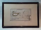
Rare antique Map of Alderney c1691 by Robert Morden with watercolor . Small scale map in nice condition framed and matted c19303s. Overall 9.75 by 6.5" map 5.25" by 3"
Jon Berg Fine Art and More
$195.00
$195.00
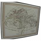
Early map titled "A Description of the Land of Goshen and Moses passage through the desert", 1614, by the English cartographer William Hole. Hole was active in cartography from about 1601 to about 1624. The map measures 10 3/4" by 14" inside the present mats (not examined out of the frame but would be happy to do so upon request). This is an uncommon map with a compass rose at lower right and cartouches at upper portion, the cartographer's name at lower left edge...
David Anthony
$29.00
$29.00
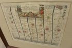
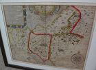
John Owen and Emanuel Bowen created innovative road maps in the early 18th C greatly aiding travelers of the day, whose publication spanned 1720-1764, titled Britannia Depicta.
This map is from pages 207/208, double-sided, and whose primary view is of Lincoln / Grimsby...
This map is from pages 207/208, double-sided, and whose primary view is of Lincoln / Grimsby...
Jon Berg Fine Art and More
$495.00
$495.00
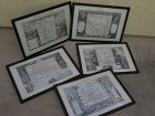
A set of five antique atlas maps, titled, "Oceanie", "Amerique Septentrionale", "Amerique Meridionale", "Europe", and "Asie", published in 1856 by A...
Jon Berg Fine Art and More
$245.00
$245.00
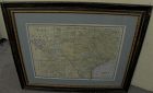
For your home or office in Texas, or elsewhere if you are homesick for the Lone Star State, a wall-ready, circa 1900 antique map of the state, by cartography publisher George F. Cram (1842-1928). Illinois-based Cram published maps in the late 19th and early 20th century in atlas form. This map came from one of those atlases. It maintains its central fold. **The map is unusually clean and fresh, considering its age.** Charmingly, we see at lower left inset map "Cheyennes and Arrapahoes" in In...
Jon Berg Fine Art and More
$175.00
$175.00
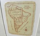
A charming completely hand-drawn map of the South American continent, likely created by a school child at a time when geography was taught to youngsters, measuring 8 1/2" by 6 1/2" (19" by 15 1/2" in black strip modern framing). The age looks to be 19th century. The creator used a red-brown ink, and pencil underlying in some places. Note the cartouche at lower right, and the quaint term "Amazonia" and "Brasil" spelling. The map has been mounted in recent times. The mat seems to have been used...
Jon Berg Fine Art and More
$1,100.00
$1,100.00
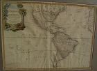
Very nicely presented, wall-ready antique map centered on the Americas, 1784, by Paris-based late 18th century cartographer Jean Janvier. The map, 19" by 25 3/4"inside the mat and 30 3/4" by 36 3/4" in new black ornate frame, is generally in fresh, clean condition, with center fold and some unevenness of the paper, which photographs as shadows or brown areas. The map features an interesting cartouche at upper left, including a beaver dam along a stream, which is bordered by palm trees on one s...
