
FEATURED ITEMS
 | Original Extradition Writ Signed by Mayor James Curley Boston 10/36 |
 | Alaskan Highway Photographic Collage |
SALE PRICED
 | Young People's Illustrated Bible History...1879 Engravings+Maps |


Hundred and One Antiques
$75.00
$75.00
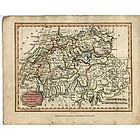
Published as the Act directs by Brightly & Kinnersley Bungay, May 1st 1807.
Copper engraved map with contemporary outline hand color.
CONDITION: in good condition.
MEASUEMENTS: 10 ¼ x 8 1/8 inches
Copper engraved map with contemporary outline hand color.
CONDITION: in good condition.
MEASUEMENTS: 10 ¼ x 8 1/8 inches
ALL ITEMS ARE GUARANTEED TO BE AUTHENTIC ANTIQUES, AND NOT REPRODUCTIONS.
ALL OUR ARTIFACTS ARE ACCOMPANIED BY A CERTIFICATE OF AUTHENTICITY.
Jon Berg Fine Art and More
$175.00
$175.00
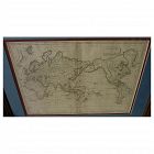
Early 19th century map of the world, in Mercator projection, the Pacific Ocean at center, titled at upper right "Mappemonde sur la Projection de Mercator", measuring 10" by 14 1/2" inside the double mats, and 16" by 21" as nicely framed. The map might date to about the 1820's. The United States is shown as "Etats Unis". There are numerous picturesque early geographic names like "Is. Sandwich/Owhyhee", "Othahiti", "Nouvelle Hollande" for Australia, The map is printed on old style paper...
Jon Berg Fine Art and More
$795.00
$795.00
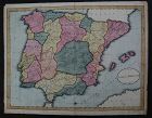
This is a HAND DRAWN map, not a print of any kind, probably crafted, with great care, by an American school child, who did not add his or her name, but did date this in the year 1809. The title is "A Map of SPAIN & PORTUGAL from the best Authorities". Unframed, it measures 16 1/8" by 20 3/4". The work contains amazing, loving detail, with towns, rivers, provinces, even mountain ranges, drawn in. The provinces are outlined and colored, creating a patchwork effect that adds to the appeal...
All Items : Traditional Collectibles : Ephemera : Autographs : Historical : Pre 1837 VR
item #1421985
(stock #JB04275)
Jon Berg Fine Art and More
$295.00
$295.00
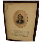
For the collector of Victoriana or autographs of noted writers, here is an authentic signature of the English 19th century novelist and satirist WILLIAM MAKEPEACE THACKERAY (1811-1863), found on what appears to be a library slip. The writing on the slip refers to the borrowing of the book "Histoire de la Reine Zarah et les Zarasiens", 1712. This little piece of history gives some indication of the reading habits of the famous author...
Hundred and One Antiques
$75.00
$75.00
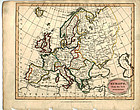
"Europe from the Best Authorities" published as the Act directs by C. Brightly & E. Kinnersley Bungay Suffolk August 24th, 1815. Copper engraved map with original
MEASUREMENTS: 10 ½ x 8 ¼ inches
MEASUREMENTS: 10 ½ x 8 ¼ inches
ALL OUR ARTIFACTS ARE ACCOMPANIED BY A CERTIFICATION OF AUTHENTICITY
WE SHIP INTERNATIONALLY
Hundred and One Antiques
$75.00
$75.00
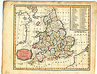
“England and Wales from the best Authorities" published as the act by Brightly & Kinnersley Bungay, February 10th, 1807. In upper corner references to the Counties. Copper engraved map with contemporary outline hand color.
Engraved by J. Barlow.
CONDITION: Good condition.
MEASUREMENTS: Size 10 ¼ x 8 1/8 inches
CONDITION: Good condition.
MEASUREMENTS: Size 10 ¼ x 8 1/8 inches
ALL OUR ARTIFACTS ARE ACCOMPANIED BY A CERTIFICATION OF AUTHENTICITY
WE SHIP INTERNATIONALLY
Jon Berg Fine Art and More
$200.00
$200.00
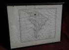
Map of the South American continent, titled "Amerique Meridionale", by Felix Delamarche, 1822. The map is on old type laid paper, and measures 12 3/4" by 16 3/4". There is a distinct plate mark and a central fold. The borders of Brazil, Peru, Chile, Patagonia and French Guyana are colored in green, yellow and blue. I do not know if the map is laid down, not having opened it up, but would be happy to do so upon request...
All Items : Traditional Collectibles : Ephemera : Autographs : Political : Pre 1837 VR
item #1415991
(stock #JB0966)

Jon Berg Fine Art and More
$975.00
$975.00
Scarce and desirable autograph signature of the 5th president of the United States, JOHN QUINCY ADAMS (1767-1848), **AND** of GEORGE GRAHAM (1772-1830), early Texas coast explorer/land grant commissioner, on a land grant document measuring 9" by 15", in a 7/8" wide simple wood frame. The land grant is referring to an 80 acre parcel in Wayne County, Michigan Territory (Detroit), and is dated February 1, 1827...
Jon Berg Fine Art and More
$125.00
$125.00
Antique small map titled "The World as known to Ptolemy", 1835, published by Joseph Thomas, London. The measurements are 5" by 6" inside the tasteful maroon map (10 1/4" by 11 1/4" framed). There is hand coloring in red outlining most of Europe. The map is very clean. Mat at lower extreme right has a bit of puckering/creasing. You could replace if so desire but most viewers would not notice this...
Jon Berg Fine Art and More
$975.00
$975.00
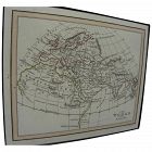
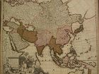
Fine antique copper engraving map of Asia from the eastern Mediterranean to the western Pacific, with hand coloring, by Dutch cartographers Gerardo and Leonardo Valk, circa 1710. The map measures 20" by 24" and is laid down to a board as is often seen. Margins are adequate...
Jon Berg Fine Art and More
$195.00
$195.00
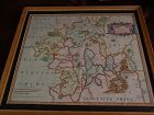
This is a very detailed map of Worcestershire in western England, first engraved by noted London map maker Robert Morden in 1695 for Camden's Britannia, and issued in several later editions in the early years of the 18th century. The map measures 14 1/4" by 16 5/8" inside the mat (17" by 19" as framed). Like most of its type it has been hand colored at a later date...

Jon Berg Fine Art and More
$425.00
$425.00
Antique French 18th century map of the Mediterranean Sea regions and the Holy Land, titled "Carte des Regions et des Lieux....Nouveaux Testament", by noted French cartographer Rigobert Bonne (1727-1794), published Paris circa 1771. Measurements inside the mat 12 1/4" by 17 3/4" (21" by 25" as framed). Bonne was one of the premier cartographers of his day, having gained a reputation for producing accurate and practical maps...
David Anthony
$34.00
$34.00
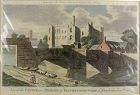
A copper engraved print from The Modern Universal British Traveler published around 1779. It is hand colored and matted.
Condition is fine to very fine. A plastic sleeve protects the print.
Dimensions (matted, inches)
Height: 11 1/2
Width: 15
Condition is fine to very fine. A plastic sleeve protects the print.
Dimensions (matted, inches)
Height: 11 1/2
Width: 15
Jon Berg Fine Art and More
$1,100.00
$1,100.00
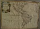
Very nicely presented, wall-ready antique map centered on the Americas, 1784, by Paris-based late 18th century cartographer Jean Janvier. The map, 19" by 25 3/4"inside the mat and 30 3/4" by 36 3/4" in new black ornate frame, is generally in fresh, clean condition, with center fold and some unevenness of the paper, which photographs as shadows or brown areas...
David Anthony
$29.00
$29.00
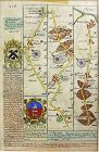
John Owen and Emanuel Bowen created innovative road maps in the early 18th C greatly aiding travelers of the day, whose publication spanned 1720-1764, titled Britannia Depicta.
This map is from pages 207/208, double-sided, and whose primary view is of Lincoln / Grimsby...
This map is from pages 207/208, double-sided, and whose primary view is of Lincoln / Grimsby...
SwisSiam-Arts-Antiques-Gems
USD $475.00
USD $475.00
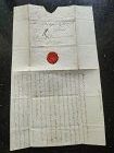
A very rare Original Letter written in black ink and bearing the Seal of the late Duchess of Richelieu (France) to Monsieur de Sinner, Berne, Switzerland, DATED 1797.
Size open letter: 18 cm. x 15 cm.
French Transcript available upon request.
Price: US$ 475
All Items : Traditional Collectibles : Ephemera : Autographs : Historical : Pre 1800
item #1480374
(stock #4118)
Watch Company
$449.00
$449.00
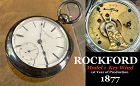
ROCKFORD WATCH CO.
Rockford, Illinois
1873 – 1915
The Rockford Watch Company’s equipment was bought from the Cornell Watch Col, and two of Cornell’s employees, C.W. Parker and P.H. Wheeler, went to work for Rockford. The factory was located 93 miles from Chicago on the Rock Rover. The first watch was placed on the market on May1, 1878. They were key wind, 18 size, full plate expansion balance and dials made by outside contract. By 1877 the company was making ¾ plate and nickel move...
David Anthony
$175.00
$175.00
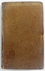
Hardcover. Condition: Good. 2nd Edition. Bound in polished leather, printed on laid paper, gilt tooling on spine, all leather spine labels intact, all covers attached, binding and hinges secure. Previous ownership: armorial bookplate for Thomas Taylor, County Devon parish Denbury. Cover fans out, cracking and minor losses of leather at the spine hinges, generally, though not perfectly, bright and clean pages.
Dimensions
Height: 7 1/2 inches Width: 4 3/4 inches
T...
Dimensions
Height: 7 1/2 inches Width: 4 3/4 inches
T...
