
AUCTIONS (3)
 | Antique NYOI scepter (ruyi); natural rekishi shape. Late Edo |
 | Elegant Bamboo Ikebana Basket, Hanakago by Suzuki Gengesai |
 | 1st ED ~ Inspiring Reform ~Boston's Arts & Crafts Movement HC/DJ |
 | Alaskan Highway Photographic Collage |
SALE PRICED
 | Young People's Illustrated Bible History...1879 Engravings+Maps |
 Traditional Collectibles (774)


Jon Berg Fine Art and More
$300.00
$300.00
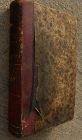
Antique book, volume 3 (originally of a set of 3), printed in Geneva, "Histoire de Geneve", originally by Jacob Spon (1647-1685), this a later improved edition published by Fabri & Barrillot in the year 1730. Small size, 6 1/2" by 4", 672 pages. No maps or imagery. The cover is worn leather (spine) and patterned paperboard...
David Anthony
$175.00
$175.00
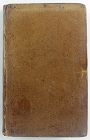
Hardcover. Condition: Good. 2nd Edition. Bound in polished leather, printed on laid paper, gilt tooling on spine, all leather spine labels intact, all covers attached, binding and hinges secure. Previous ownership: armorial bookplate for Thomas Taylor, County Devon parish Denbury...
Jon Berg Fine Art and More
$195.00
$195.00
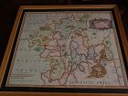
This is a very detailed map of Worcestershire in western England, first engraved by noted London map maker Robert Morden in 1695 for Camden's Britannia, and issued in several later editions in the early years of the 18th century. The map measures 14 1/4" by 16 5/8" inside the mat (17" by 19" as framed). Like most of its type it has been hand colored at a later date...
Senatus Consulto
$1,495.00
$1,495.00
A lovely chestnut brown patinated plate coin 1/2 daler 1716 from Karl the XII (1697-1718).
These platecoins are very seldomly this nice: Finely struck stamps, wonderful metal and a fine patina. Bears an old 1980s-1990s pricetag of 6800 d. kr.
Size: 10,5 cm. in diameter and weighing ca. 370 grams.
Ex Private Danish Collection.
These platecoins are very seldomly this nice: Finely struck stamps, wonderful metal and a fine patina. Bears an old 1980s-1990s pricetag of 6800 d. kr.
Size: 10,5 cm. in diameter and weighing ca. 370 grams.
Ex Private Danish Collection.
STUDIO ANTIQUES & FINE ART, INC.
$450.00
$450.00
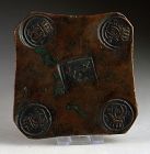
A Rare Stoneware Wine Flask (called a “Schraubflasche” in German), cylindrical with a pewter screw top, sloped shoulder and white glazed body with applied silvered decoration of a scrolling branch with leaves and berries. Silvered underglazed mark on base.
Probably German, 18th Century (chip to base)
Height: 5.25"
Diameter: 3"
All Items : Traditional Collectibles : Wine and Related : Coasters : Pre 1800
item #1475935
(stock #4107)

Watch Company
$750.00
$750.00
AMERICAN WATCH CO.
1859 – 1873
Boston, Mass.
Commonly referred to as “The Mother of all American Watch Companies”, this manufacturer was a international pioneer in watch production and accuracy. They were the first to gain independence from European watch providers in the New World. But more than that, they sought to provide a more accurate watch at a affordable price to the American Citizen. After beginning activity in Boston by the Boston Watch Co...
All Items : Traditional Collectibles : Numismatics : Coins : Asian : Pre 1800
item #1451835
(stock #7145)
Abhaya Asian Antiques
$110.00
$110.00
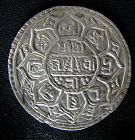
Silver Nepal, Mohar Bhupatindra Malla, mohar circa 1696-1722CE. D: 28mm, 6grams. VG. Free shipping.
Jon Berg Fine Art and More
$150.00
$150.00
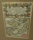
A very nice example of the 1753 map "The Smaller Islands in the British Ocean", published by T. Bowles, London, engraved by Emmanuel Owen, text by John Owen, the map featuring the Isle of Wight, Scilly Islands in the far southwest, the Channel Islands of Guernsey, Jersey, and Alderney, as well as Farne Island and Holy Island. At top is given the mile marker landmarks on the road from London to Southampton. Beautiful unusually good quality hand-coloring and condition is excellent...
All Items : Traditional Collectibles : Numismatics : Coins : Asian : Pre 1800
item #1451900
(stock #7146)
Abhaya Asian Antiques
$110.00
$110.00
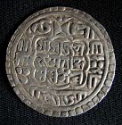
Silver Nepali mohar, from the reign of Prithvi Narayan Shah circa 1768-1775CE. VG. D: 29mm, 6 grams.
Jon Berg Fine Art and More
$1,100.00
$1,100.00
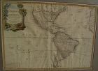
Very nicely presented, wall-ready antique map centered on the Americas, 1784, by Paris-based late 18th century cartographer Jean Janvier. The map, 19" by 25 3/4"inside the mat and 30 3/4" by 36 3/4" in new black ornate frame, is generally in fresh, clean condition, with center fold and some unevenness of the paper, which photographs as shadows or brown areas...

Jon Berg Fine Art and More
$200.00
$200.00
An original copper plate engraved map, with hand coloring of country outlines, and also in the cartouche, titled there, at lower left, "A Map of Turky, Arabia and Persia", the first edition by Georges de l'Isle in 1701, this being the somewhat later revised 1721 edition by noted cartographer of the day John Senex (1678-ca. 1740). This map, 19" by 23" (22 1/2" by 26 1/2" as framed) was considered to be the first modern map of the Arabian Peninsula before the middle of the 18th century...
David Anthony
$29.00
$29.00
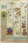
John Owen and Emanuel Bowen created innovative road maps in the early 18th C greatly aiding travelers of the day, whose publication spanned 1720-1764, titled Britannia Depicta.
This map is from pages 207/208, double-sided, and whose primary view is of Lincoln / Grimsby...
This map is from pages 207/208, double-sided, and whose primary view is of Lincoln / Grimsby...

Jon Berg Fine Art and More
$425.00
$425.00
Antique French 18th century map of the Mediterranean Sea regions and the Holy Land, titled "Carte des Regions et des Lieux....Nouveaux Testament", by noted French cartographer Rigobert Bonne (1727-1794), published Paris circa 1771. Measurements inside the mat 12 1/4" by 17 3/4" (21" by 25" as framed). Bonne was one of the premier cartographers of his day, having gained a reputation for producing accurate and practical maps...
David Anthony
$34.00
$34.00
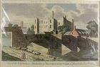
A copper engraved print from The Modern Universal British Traveler published around 1779. It is hand colored and matted.
Condition is fine to very fine. A plastic sleeve protects the print.
Dimensions (matted, inches)
Height: 11 1/2
Width: 15
Condition is fine to very fine. A plastic sleeve protects the print.
Dimensions (matted, inches)
Height: 11 1/2
Width: 15
All Items : Traditional Collectibles : Numismatics : Coins : Asian : Pre 1800
item #1446775
(stock #7042)
Abhaya Asian Antiques
$100.00
$100.00
100.00
Rare 1787 British East India Penang half cent coin, Balemark series. D: 17mm, weight 4 grams. Free shipping.
Jon Berg Fine Art and More
$975.00
$975.00
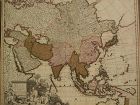
Fine antique copper engraving map of Asia from the eastern Mediterranean to the western Pacific, with hand coloring, by Dutch cartographers Gerardo and Leonardo Valk, circa 1710. The map measures 20" by 24" and is laid down to a board as is often seen. Margins are adequate...
Asian Works of Art Gallery
Please ask
Please ask
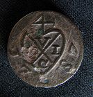
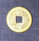
A rare authentic Qing Dynasty cash coin in extremely fine condition , the copper is with nice original patina and in very nice coloration
SwisSiam-Arts-Antiques-Gems
USD $475.00
USD $475.00
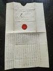
A very rare Original Letter written in black ink and bearing the Seal of the late Duchess of Richelieu (France) to Monsieur de Sinner, Berne, Switzerland, DATED 1797.
Size open letter: 18 cm. x 15 cm.
French Transcript available upon request.
Price: US$ 475