
FEATURED ITEMS
 | "Effective English": Edward Frank Allen, 1938 |
 | Encyclopedia Britannica hello! |
SALE PRICED
 | Young People's Illustrated Bible History...1879 Engravings+Maps |
 |
 |
| Large nicely framed 1784 antique map "L'Amerique divisee en Ses principaux Etats" | Showa Reign - General Military Map of Troops Deployment |
Items above include suggestions and sponsored listings. |
|

EL-GALLERY
USD $1,500.00
USD $1,500.00
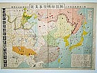
This is a Japanese military map of North Asia dated 25th/29th July, 12 Year of Showa reign. This is translated to the 12th year of Emperor Hirohito’s reign. He became emperor in 1926 and died in 1989. Add the 12 year to 1926 that translate the map dating to 1938.
This is a general Japanese military map of North Asia of the Japanese troop deployment and the armies that they are fighting against...
Jon Berg Fine Art and More
$245.00
$245.00
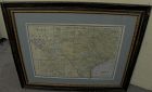
For your home or office in Texas, or elsewhere if you are homesick for the Lone Star State, a wall-ready, circa 1900 antique map of the state, by cartography publisher George F. Cram (1842-1928). Illinois-based Cram published maps in the late 19th and early 20th century in atlas form. This map came from one of those atlases. It maintains its central fold...
Jon Berg Fine Art and More
$75.00
$75.00
An original engraved map, titled "A Map of the Genesee Lands in the County of Ontario and State of New York according to an accurate survey which was made of the same 1790", printed in the year 1849 by engraver Richard H. Pease of Albany (1813-1869; his name at extreme bottom). The map shows Lake Ontario at top and the Finger Lakes region from Canandaigua Lake at the far right to generally the Genesee River at left...
Jon Berg Fine Art and More
$225.00
$225.00
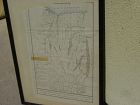
For the collector of things relating to the history of the state of Missouri, here is an early survey map drawn completely by hand, titled at top "Estate of Jos. Hickam decd. in 1848...", signed at bottom right by the surveyor, one W.W. Trent of Cooper County. Cooper County is near today's I-70, roughly between Boonville, Missouri and Columbia, Missouri...
Jon Berg Fine Art and More
$495.00
$495.00
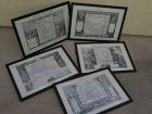
A set of five antique atlas maps, titled, "Oceanie", "Amerique Septentrionale", "Amerique Meridionale", "Europe", and "Asie", published in 1856 by A. Combette, and printed by Alfred Lemercier, Paris, after cartography by Victor Levasseur. The set is framed identically in dark, "distressed" style modern framing of good quality (each measures 15" by 22"). Maps are very clean, considering the age, with only the stray fox mark here and there...
Jon Berg Fine Art and More
$175.00
$175.00
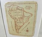
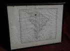
A charming completely hand-drawn map of the South American continent, likely created by a school child at a time when geography was taught to youngsters, measuring 8 1/2" by 6 1/2" (19" by 15 1/2" in black strip modern framing). The age looks to be 19th century. The creator used a red-brown ink, and pencil underlying in some places. Note the cartouche at lower right, and the quaint term "Amazonia" and "Brasil" spelling. The map has been mounted in recent times...
Jon Berg Fine Art and More
$325.00
$325.00
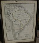
Found in New Hampshire, this is a beautifully and meticulously drawn map of the South American continent, from the Isthmus of Panama to Cape Horn, signed at lower right one "Rosa W. Miner" (or, "Mines"). The work, which measures 13" by 10" in a simple earlier 20th century frame, is drawn in pencil, with watercolor forming the borders of the various countries...
Hundred and One Antiques
$75.00
$75.00
Published as the Act directs by Brightly & Kinnersley Bungay, May 1st 1807.
Copper engraved map with contemporary outline hand color.
CONDITION: in good condition.
MEASUEMENTS: 10 ¼ x 8 1/8 inches
Copper engraved map with contemporary outline hand color.
CONDITION: in good condition.
MEASUEMENTS: 10 ¼ x 8 1/8 inches
ALL ITEMS ARE GUARANTEED TO BE AUTHENTIC ANTIQUES, AND NOT REPRODUCTIONS.
ALL OUR ARTIFACTS ARE ACCOMPANIED BY A CERTIFICATE OF AUTHENTICITY.

what pdx
$285.00
$285.00
Very large engraved map of Denmark and parts of the surrounding countries important cities, mountains, rivers, and lakes. Insets of Iceland and the Faroe Islands . Designed and engraved for Thompson's "New General Atlas" July 14 1814 hand pastel colors. Great condition size 21" by 26 "
Jon Berg Fine Art and More
$125.00
$125.00
Antique small map titled "The World as known to Ptolemy", 1835, published by Joseph Thomas, London. The measurements are 5" by 6" inside the tasteful maroon map (10 1/4" by 11 1/4" framed). There is hand coloring in red outlining most of Europe. The map is very clean. Mat at lower extreme right has a bit of puckering/creasing. You could replace if so desire but most viewers would not notice this...
Hundred and One Antiques
$75.00
$75.00
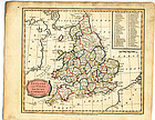
“England and Wales from the best Authorities" published as the act by Brightly & Kinnersley Bungay, February 10th, 1807. In upper corner references to the Counties. Copper engraved map with contemporary outline hand color.
Engraved by J. Barlow.
CONDITION: Good condition.
MEASUREMENTS: Size 10 ¼ x 8 1/8 inches
CONDITION: Good condition.
MEASUREMENTS: Size 10 ¼ x 8 1/8 inches
ALL OUR ARTIFACTS ARE ACCOMPANIED BY A CERTIFICATION OF AUTHENTICITY
WE SHIP INTERNATIONALLY
Jon Berg Fine Art and More
$795.00
$795.00
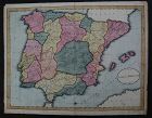
This is a HAND DRAWN map, not a print of any kind, probably crafted, with great care, by an American school child, who did not add his or her name, but did date this in the year 1809. The title is "A Map of SPAIN & PORTUGAL from the best Authorities". Unframed, it measures 16 1/8" by 20 3/4"...
Jon Berg Fine Art and More
$175.00
$175.00
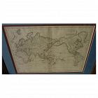
Early 19th century map of the world, in Mercator projection, the Pacific Ocean at center, titled at upper right "Mappemonde sur la Projection de Mercator", measuring 10" by 14 1/2" inside the double mats, and 16" by 21" as nicely framed. The map might date to about the 1820's. The United States is shown as "Etats Unis". There are numerous picturesque early geographic names like "Is. Sandwich/Owhyhee", "Othahiti", "Nouvelle Hollande" for Australia, The map is printed on old style paper. Othe...
Hundred and One Antiques
$75.00
$75.00
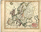
"Europe from the Best Authorities" published as the Act directs by C. Brightly & E. Kinnersley Bungay Suffolk August 24th, 1815. Copper engraved map with original
MEASUREMENTS: 10 ½ x 8 ¼ inches
MEASUREMENTS: 10 ½ x 8 ¼ inches
ALL OUR ARTIFACTS ARE ACCOMPANIED BY A CERTIFICATION OF AUTHENTICITY
WE SHIP INTERNATIONALLY
Jon Berg Fine Art and More
$200.00
$200.00
Map of the South American continent, titled "Amerique Meridionale", by Felix Delamarche, 1822. The map is on old type laid paper, and measures 12 3/4" by 16 3/4". There is a distinct plate mark and a central fold. The borders of Brazil, Peru, Chile, Patagonia and French Guyana are colored in green, yellow and blue. I do not know if the map is laid down, not having opened it up, but would be happy to do so upon request. There are seven separate dark stains, all except for one in the margins,...
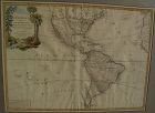
Jon Berg Fine Art and More
$1,100.00
$1,100.00
Very nicely presented, wall-ready antique map centered on the Americas, 1784, by Paris-based late 18th century cartographer Jean Janvier. The map, 19" by 25 3/4"inside the mat and 30 3/4" by 36 3/4" in new black ornate frame, is generally in fresh, clean condition, with center fold and some unevenness of the paper, which photographs as shadows or brown areas. The map features an interesting cartouche at upper left, including a beaver dam along a stream, which is bordered by palm trees on one s...

Jon Berg Fine Art and More
$425.00
$425.00
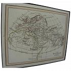
Antique French 18th century map of the Mediterranean Sea regions and the Holy Land, titled "Carte des Regions et des Lieux....Nouveaux Testament", by noted French cartographer Rigobert Bonne (1727-1794), published Paris circa 1771. Measurements inside the mat 12 1/4" by 17 3/4" (21" by 25" as framed). Bonne was one of the premier cartographers of his day, having gained a reputation for producing accurate and practical maps. He succeeded the well-known Jacques-Nicolas Bellin as Royal Cartograp...

Jon Berg Fine Art and More
$200.00
$200.00
An original copper plate engraved map, with hand coloring of country outlines, and also in the cartouche, titled there, at lower left, "A Map of Turky, Arabia and Persia", the first edition by Georges de l'Isle in 1701, this being the somewhat later revised 1721 edition by noted cartographer of the day John Senex (1678-ca. 1740). This map, 19" by 23" (22 1/2" by 26 1/2" as framed) was considered to be the first modern map of the Arabian Peninsula before the middle of the 18th century. The geog...
