
AUCTIONS (2)
 | Antique Tibetan painted wood image of Green Tara Bodhisattva |
 | Fine quality Ohi Ware Macha bowl by Yoshio Iwamura |
 | Rolex 16mm Yellow Plate Buckle 20mm Forest Green Genuine Crocodile |
 | Songs, Sacred and Devotional ~ H.O. John Foster 1880 |
SALE PRICED
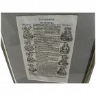
 | Young People's Illustrated Bible History...1879 Engravings+Maps |


Jon Berg Fine Art and More
$275.00
$275.00
The Nuremberg Chronicles is considered a landmark work in the history of the printed book, and an example of incunabulum (book printed before the year 1500). Described in Wikipedia as essentially a biblical paraphrase, and a history of the known world to that date, it is one of the most extensively illustrated books of the 15th century, considered one of the first to successfully integrate illustrations and text...
All Items : Traditional Collectibles : Ephemera : Manuscripts : Pre 1492
item #1423589
(stock #JB03792)
Jon Berg Fine Art and More
$600.00
$600.00
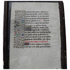
An page from a fifteenth century "Book of Hours", DOUBLE SIDED, page 6 3/4" by 4 3/4, framed with glass on both sides to facilitate viewing. There are 16 lines of text in Latin, decorative borders and capitals with extensive use of gold. According to Wikipedia, books of hours were Christian devotional books popular in the Middle Ages. They are considered the most common type of surviving medieval illustrated manuscripts. Generally they contained prayers and psalms...
Jon Berg Fine Art and More
$400.00
$400.00
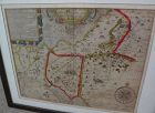
An example of an original 17th century copper engraving map with later hand coloring, titled "The Road from Oxford to Cambridge", from the first road atlas of England and Wales, by noted mapmaker JOHN OGILBY (1600-1676). The piece measures 14 1/2" by 17 1/2" inside the mat, 26 1/2" by 28 1/2" as framed...
what pdx
$195.00
$195.00
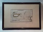
Rare antique Map of Alderney c1691 by Robert Morden with watercolor . Small scale map in nice condition framed and matted c19303s. Overall 9.75 by 6.5" map 5.25" by 3"
Jon Berg Fine Art and More
$225.00
$225.00
Antique early map of central England's Oxfordshire county, by cartographer Robert Morden, originally published in 1695. This map is nicely hand colored. It measures 17" by 15" inside the green mat and 24" by 22" framed (no glass). The mat was seemingly permanently affixed over the margins of the map by the framer, but the central portion of the map does not appear to be laid down as there is play to the surface. There is central horizontal crease and slight handling creases in the field...
Jon Berg Fine Art and More
$195.00
$195.00
Early map titled "A Description of the Land of Goshen and Moses passage through the desert", 1614, by the English cartographer William Hole. Hole was active in cartography from about 1601 to about 1624. The map measures 10 3/4" by 14" inside the present mats (not examined out of the frame but would be happy to do so upon request). This is an uncommon map with a compass rose at lower right and cartouches at upper portion, the cartographer's name at lower left edge...
Jon Berg Fine Art and More
$325.00
$325.00
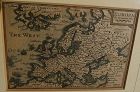
This is a miniature map, 3 3/8" by 4 7/8" inside the mat, titled at upper right "EUROPA", and bearing at lower right the name of the engraver cartographer, Pieter van den Keere (Petrus Kaerius). The entire sweep of Europe is shown, from Greenland and Atlantic islands on the west to as far east as Turkey, the Middle East, and "Tartaria". Kaerius (circa 1571-1646) was born in the Low Countries and fled to London due to religious persecution, in 1584...
All Items : Traditional Collectibles : Ephemera : Manuscripts : Pre 1700
item #1423011
(stock #JB04544)
Jon Berg Fine Art and More
$295.00
$295.00
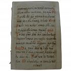
A miniature size hand written in Latin manuscript page, double sided, measuring 4 1/4" by 3", and 8 1/2" by 6 1/2" nicely framed, likely of religious content. Written neatly in brown ink with red capitals in places, much as would be seen in an antiphonal sheet. Condition of this little item, a survivor at many hundreds of years old, is excellent.
Senatus Consulto
$950.00
$950.00
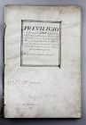
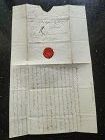
A very rare and complete antique license document, Spanish and signed by the Spanish King Philip the IV (Ruler 1621-1665).
The document is binded with 8/16 pages with 14 decorated or with signatures (let us know if you like to receive pictures of all pages by e-mail). We would like to stress the importance of the document which signed by no less than 15-20 signatures, besides the signature of Philip himself...
The document is binded with 8/16 pages with 14 decorated or with signatures (let us know if you like to receive pictures of all pages by e-mail). We would like to stress the importance of the document which signed by no less than 15-20 signatures, besides the signature of Philip himself...
Jon Berg Fine Art and More
$195.00
$195.00
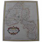
This is a very detailed map of Worcestershire in western England, first engraved by noted London map maker Robert Morden in 1695 for Camden's Britannia, and issued in several later editions in the early years of the 18th century. The map measures 14 1/4" by 16 5/8" inside the mat (17" by 19" as framed). Like most of its type it has been hand colored at a later date...
David Anthony
$29.00
$29.00
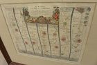
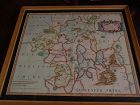
John Owen and Emanuel Bowen created innovative road maps in the early 18th C greatly aiding travelers of the day, whose publication spanned 1720-1764, titled Britannia Depicta.
This map is from pages 207/208, double-sided, and whose primary view is of Lincoln / Grimsby...
This map is from pages 207/208, double-sided, and whose primary view is of Lincoln / Grimsby...
Jon Berg Fine Art and More
$1,100.00
$1,100.00
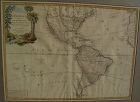
Very nicely presented, wall-ready antique map centered on the Americas, 1784, by Paris-based late 18th century cartographer Jean Janvier. The map, 19" by 25 3/4"inside the mat and 30 3/4" by 36 3/4" in new black ornate frame, is generally in fresh, clean condition, with center fold and some unevenness of the paper, which photographs as shadows or brown areas...
David Anthony
$34.00
$34.00
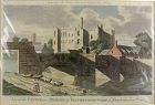
A copper engraved print from The Modern Universal British Traveler published around 1779. It is hand colored and matted.
Condition is fine to very fine. A plastic sleeve protects the print.
Dimensions (matted, inches)
Height: 11 1/2
Width: 15
Condition is fine to very fine. A plastic sleeve protects the print.
Dimensions (matted, inches)
Height: 11 1/2
Width: 15

Jon Berg Fine Art and More
$200.00
$200.00
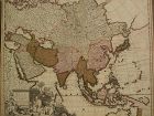
An original copper plate engraved map, with hand coloring of country outlines, and also in the cartouche, titled there, at lower left, "A Map of Turky, Arabia and Persia", the first edition by Georges de l'Isle in 1701, this being the somewhat later revised 1721 edition by noted cartographer of the day John Senex (1678-ca. 1740). This map, 19" by 23" (22 1/2" by 26 1/2" as framed) was considered to be the first modern map of the Arabian Peninsula before the middle of the 18th century...
Jon Berg Fine Art and More
$975.00
$975.00
Fine antique copper engraving map of Asia from the eastern Mediterranean to the western Pacific, with hand coloring, by Dutch cartographers Gerardo and Leonardo Valk, circa 1710. The map measures 20" by 24" and is laid down to a board as is often seen. Margins are adequate...
Jon Berg Fine Art and More
$700.00
$700.00
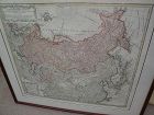
Original map printed in the year 1739 in Nuremberg, Germany, titled in cartouche at upper left "Imperii Russici et Tartariae Universiae", published by the heirs of important cartographer Johann Baptiste Homanns. The attractive map shows most of Asia from the Baltic Sea to the Pacific Ocean, and from the Arctic Ocean to India, including the Korean peninsula, Japan, and Taiwan. The map measures 20" by 22 1/2" inside the mat and 25 1/2" by 28" as framed. Condition is excellent. I see at least o...
SwisSiam-Arts-Antiques-Gems
USD $475.00
USD $475.00
A very rare Original Letter written in black ink and bearing the Seal of the late Duchess of Richelieu (France) to Monsieur de Sinner, Berne, Switzerland, DATED 1797.
Size open letter: 18 cm. x 15 cm.
French Transcript available upon request.
Price: US$ 475

Jon Berg Fine Art and More
$425.00
$425.00
Antique French 18th century map of the Mediterranean Sea regions and the Holy Land, titled "Carte des Regions et des Lieux....Nouveaux Testament", by noted French cartographer Rigobert Bonne (1727-1794), published Paris circa 1771. Measurements inside the mat 12 1/4" by 17 3/4" (21" by 25" as framed). Bonne was one of the premier cartographers of his day, having gained a reputation for producing accurate and practical maps. He succeeded the well-known Jacques-Nicolas Bellin as Royal Cartograp...
David Anthony
$175.00
$175.00
Hardcover. Condition: Good. 2nd Edition. Bound in polished leather, printed on laid paper, gilt tooling on spine, all leather spine labels intact, all covers attached, binding and hinges secure. Previous ownership: armorial bookplate for Thomas Taylor, County Devon parish Denbury. Cover fans out, cracking and minor losses of leather at the spine hinges, generally, though not perfectly, bright and clean pages.
Dimensions
Height: 7 1/2 inches Width: 4 3/4 inches
T...
Dimensions
Height: 7 1/2 inches Width: 4 3/4 inches
T...
All Items : Traditional Collectibles : Ephemera : Autographs : Historical : Pre 1800
item #1480374
(stock #4118)
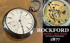
Watch Company
$449.00
$449.00
ROCKFORD WATCH CO.
Rockford, Illinois
1873 – 1915
The Rockford Watch Company’s equipment was bought from the Cornell Watch Col, and two of Cornell’s employees, C.W. Parker and P.H. Wheeler, went to work for Rockford. The factory was located 93 miles from Chicago on the Rock Rover. The first watch was placed on the market on May1, 1878. They were key wind, 18 size, full plate expansion balance and dials made by outside contract. By 1877 the company was making ¾ plate and nickel move...
Jon Berg Fine Art and More
$150.00
$150.00
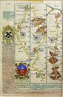
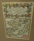
A very nice example of the 1753 map "The Smaller Islands in the British Ocean", published by T. Bowles, London, engraved by Emmanuel Owen, text by John Owen, the map featuring the Isle of Wight, Scilly Islands in the far southwest, the Channel Islands of Guernsey, Jersey, and Alderney, as well as Farne Island and Holy Island. At top is given the mile marker landmarks on the road from London to Southampton. Beautiful unusually good quality hand-coloring and condition is excellent. Nicely frame...
Jon Berg Fine Art and More
$125.00
$125.00
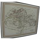
Antique small map titled "The World as known to Ptolemy", 1835, published by Joseph Thomas, London. The measurements are 5" by 6" inside the tasteful maroon map (10 1/4" by 11 1/4" framed). There is hand coloring in red outlining most of Europe. The map is very clean. Mat at lower extreme right has a bit of puckering/creasing. You could replace if so desire but most viewers would not notice this. Ptolemy was a Greco-Egyptian astronomer, geographer and mathematician who lived in Alexandria,...
Jon Berg Fine Art and More
$200.00
$200.00
Map of the South American continent, titled "Amerique Meridionale", by Felix Delamarche, 1822. The map is on old type laid paper, and measures 12 3/4" by 16 3/4". There is a distinct plate mark and a central fold. The borders of Brazil, Peru, Chile, Patagonia and French Guyana are colored in green, yellow and blue. I do not know if the map is laid down, not having opened it up, but would be happy to do so upon request. There are seven separate dark stains, all except for one in the margins,...
All Items : Traditional Collectibles : Ephemera : Autographs : Historical : Pre 1837 VR
item #1421985
(stock #JB04275)
Jon Berg Fine Art and More
$295.00
$295.00
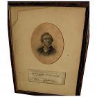
For the collector of Victoriana or autographs of noted writers, here is an authentic signature of the English 19th century novelist and satirist WILLIAM MAKEPEACE THACKERAY (1811-1863), found on what appears to be a library slip. The writing on the slip refers to the borrowing of the book "Histoire de la Reine Zarah et les Zarasiens", 1712. This little piece of history gives some indication of the reading habits of the famous author. Condition of the slip is typical of what would be expected...
All Items : Traditional Collectibles : Ephemera : Autographs : Historical : Pre 1837 VR
item #1423515
(stock #JB03504)
Jon Berg Fine Art and More
$800.00
$800.00
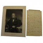
Rare original handwritten letter, apparently dating to the year 1801, by the famous, iconic English-language historical novelist, playwright, poet, and judge SIR WALTER SCOTT (1771-1832). This is a folded sheet of ancient paper, measuring 8" by 5", two sides of which bear writing. When acquired it was in a frame with the engraved image of him, as autograph materials are often framed. The old tape has dried so they were moving around loose inside, and therefore I have photographed the two piec...
Jon Berg Fine Art and More
$175.00
$175.00
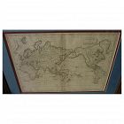
Early 19th century map of the world, in Mercator projection, the Pacific Ocean at center, titled at upper right "Mappemonde sur la Projection de Mercator", measuring 10" by 14 1/2" inside the double mats, and 16" by 21" as nicely framed. The map might date to about the 1820's. The United States is shown as "Etats Unis". There are numerous picturesque early geographic names like "Is. Sandwich/Owhyhee", "Othahiti", "Nouvelle Hollande" for Australia, The map is printed on old style paper. Othe...
Jon Berg Fine Art and More
$795.00
$795.00
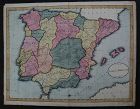
This is a HAND DRAWN map, not a print of any kind, probably crafted, with great care, by an American school child, who did not add his or her name, but did date this in the year 1809. The title is "A Map of SPAIN & PORTUGAL from the best Authorities". Unframed, it measures 16 1/8" by 20 3/4". The work contains amazing, loving detail, with towns, rivers, provinces, even mountain ranges, drawn in. The provinces are outlined and colored, creating a patchwork effect that adds to the appeal. The...
Hundred and One Antiques
$75.00
$75.00
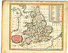
“England and Wales from the best Authorities" published as the act by Brightly & Kinnersley Bungay, February 10th, 1807. In upper corner references to the Counties. Copper engraved map with contemporary outline hand color.
Engraved by J. Barlow.
CONDITION: Good condition.
MEASUREMENTS: Size 10 ¼ x 8 1/8 inches
CONDITION: Good condition.
MEASUREMENTS: Size 10 ¼ x 8 1/8 inches
ALL OUR ARTIFACTS ARE ACCOMPANIED BY A CERTIFICATION OF AUTHENTICITY
WE SHIP INTERNATIONALLY
Hundred and One Antiques
$75.00
$75.00
Published as the Act directs by Brightly & Kinnersley Bungay, May 1st 1807.
Copper engraved map with contemporary outline hand color.
CONDITION: in good condition.
MEASUEMENTS: 10 ¼ x 8 1/8 inches
Copper engraved map with contemporary outline hand color.
CONDITION: in good condition.
MEASUEMENTS: 10 ¼ x 8 1/8 inches
ALL ITEMS ARE GUARANTEED TO BE AUTHENTIC ANTIQUES, AND NOT REPRODUCTIONS.
ALL OUR ARTIFACTS ARE ACCOMPANIED BY A CERTIFICATE OF AUTHENTICITY.
All Items : Traditional Collectibles : Ephemera : Autographs : Political : Pre 1837 VR
item #1415991
(stock #JB0966)

Jon Berg Fine Art and More
$975.00
$975.00
Scarce and desirable autograph signature of the 5th president of the United States, JOHN QUINCY ADAMS (1767-1848), **AND** of GEORGE GRAHAM (1772-1830), early Texas coast explorer/land grant commissioner, on a land grant document measuring 9" by 15", in a 7/8" wide simple wood frame. The land grant is referring to an 80 acre parcel in Wayne County, Michigan Territory (Detroit), and is dated February 1, 1827. Adams was the son of President John Adams and served as US president himself from 1825...

what pdx
$285.00
$285.00
Very large engraved map of Denmark and parts of the surrounding countries important cities, mountains, rivers, and lakes. Insets of Iceland and the Faroe Islands . Designed and engraved for Thompson's "New General Atlas" July 14 1814 hand pastel colors. Great condition size 21" by 26 "
Hundred and One Antiques
$75.00
$75.00
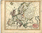
"Europe from the Best Authorities" published as the Act directs by C. Brightly & E. Kinnersley Bungay Suffolk August 24th, 1815. Copper engraved map with original
MEASUREMENTS: 10 ½ x 8 ¼ inches
MEASUREMENTS: 10 ½ x 8 ¼ inches
ALL OUR ARTIFACTS ARE ACCOMPANIED BY A CERTIFICATION OF AUTHENTICITY
WE SHIP INTERNATIONALLY
Global Ceramics
$70.00
$70.00
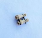
A late 19th century souvenir: miniature bone binoculars depicting Catskill Mountain House, another hotel building, waterfalls and more (can be seen, but not photographed). These truly minimal magnifying lenses were invented in the 18th century by Lord Stanhope. Measures: "1/2 x 1/3 / 12 x 9 mm. Condition: some general wear consisting with time, but both lenses are working.
Jon Berg Fine Art and More
$495.00
$495.00
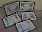
A set of five antique atlas maps, titled, "Oceanie", "Amerique Septentrionale", "Amerique Meridionale", "Europe", and "Asie", published in 1856 by A. Combette, and printed by Alfred Lemercier, Paris, after cartography by Victor Levasseur. The set is framed identically in dark, "distressed" style modern framing of good quality (each measures 15" by 22"). Maps are very clean, considering the age, with only the stray fox mark here and there. There is hand coloring of the boundaries of countries,...
Jon Berg Fine Art and More
$225.00
$225.00
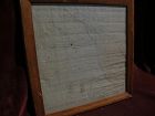
For the collector of things relating to the history of the state of Missouri, here is an early survey map drawn completely by hand, titled at top "Estate of Jos. Hickam decd. in 1848...", signed at bottom right by the surveyor, one W.W. Trent of Cooper County. Cooper County is near today's I-70, roughly between Boonville, Missouri and Columbia, Missouri. I googled these names and found considerable information on the surveyor, who apparently was in the records until at least 1889 from what I h...
Jon Berg Fine Art and More
$175.00
$175.00
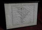
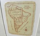
A charming completely hand-drawn map of the South American continent, likely created by a school child at a time when geography was taught to youngsters, measuring 8 1/2" by 6 1/2" (19" by 15 1/2" in black strip modern framing). The age looks to be 19th century. The creator used a red-brown ink, and pencil underlying in some places. Note the cartouche at lower right, and the quaint term "Amazonia" and "Brasil" spelling. The map has been mounted in recent times. The mat seems to have been used...
