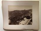
A landscape albumen photograph of Darjeeling India. Titled in script in the negative, “534. Darjeeling. General view with the Snows(?) from Woodland’s Hotel.” Presumably, “the Snows” are the snow-covered peaks of the Himalayas that show more as a line of clouds, but are visible in the distance. The details of the image are sharp at the center, but blur slightly at the edges.
Condition: slight surface dings to the image...
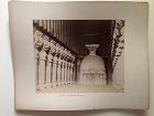
Albumen photograph mounted on a stiff card with the title, “Interior of Carlee Caves” written in ink below the image. The Karla Caves are a group of ancient Indian Buddhist rock-cut caves located in Karli near Lonavala, Maharashtra. The one pictured is the Great Chaitya. It was dedicated in 120 CE. The photographer of this image is unknown...
No. 02 = Bonfils No. 1460: Matareyeh - Park with group of ostriches.
No. 03 = Zangaki No. 495: Cairo - General view of the citadel.
No. 04 = Bonfils No. 1363: Cairo - General view of tombs of califsand citadel.
No. 05 = Bonfils No. 1109: Cairo - Mosque Kait-Bey.
No. 06 = Bonfils No. 1369: Cairo - Mosque of al Azhar.
No. 07 = Bonfils No. 1371: Cairo - Mosque of al Azhar, the courtyard.
No. 08 = Bonfils No. 1089: Cairo - The mosque of Amr Ibn al-As.
No...
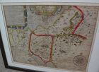
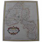
Very large engraved map of Denmark and parts of the surrounding countries important cities, mountains, rivers, and lakes. Insets of Iceland and the Faroe Islands . Designed and engraved for Thompson's "New General Atlas" July 14 1814 hand pastel colors. Great condition size 21" by 26 "
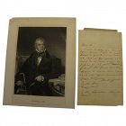
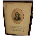
Rare original handwritten letter, apparently dating to the year 1801, by the famous, iconic English-language historical novelist, playwright, poet, and judge SIR WALTER SCOTT (1771-1832). This is a folded sheet of ancient paper, measuring 8" by 5", two sides of which bear writing. When acquired it was in a frame with the engraved image of him, as autograph materials are often framed...
Published as the Act directs by Brightly & Kinnersley Bungay, May 1st 1807.
Copper engraved map with contemporary outline hand color.
CONDITION: in good condition.
MEASUEMENTS: 10 ¼ x 8 1/8 inches
ALL ITEMS ARE GUARANTEED TO BE AUTHENTIC ANTIQUES, AND NOT REPRODUCTIONS.
ALL OUR ARTIFACTS ARE ACCOMPANIED BY A CERTIFICATE OF AUTHENTICITY.
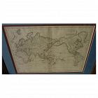
Early 19th century map of the world, in Mercator projection, the Pacific Ocean at center, titled at upper right "Mappemonde sur la Projection de Mercator", measuring 10" by 14 1/2" inside the double mats, and 16" by 21" as nicely framed. The map might date to about the 1820's. The United States is shown as "Etats Unis". There are numerous picturesque early geographic names like "Is. Sandwich/Owhyhee", "Othahiti", "Nouvelle Hollande" for Australia, The map is printed on old style paper...
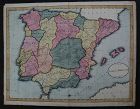
This is a HAND DRAWN map, not a print of any kind, probably crafted, with great care, by an American school child, who did not add his or her name, but did date this in the year 1809. The title is "A Map of SPAIN & PORTUGAL from the best Authorities". Unframed, it measures 16 1/8" by 20 3/4". The work contains amazing, loving detail, with towns, rivers, provinces, even mountain ranges, drawn in. The provinces are outlined and colored, creating a patchwork effect that adds to the appeal...
Scarce and desirable autograph signature of the 5th president of the United States, JOHN QUINCY ADAMS (1767-1848), **AND** of GEORGE GRAHAM (1772-1830), early Texas coast explorer/land grant commissioner, on a land grant document measuring 9" by 15", in a 7/8" wide simple wood frame. The land grant is referring to an 80 acre parcel in Wayne County, Michigan Territory (Detroit), and is dated February 1, 1827...
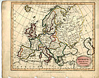
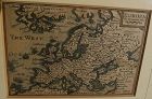
"Europe from the Best Authorities" published as the Act directs by C. Brightly & E. Kinnersley Bungay Suffolk August 24th, 1815. Copper engraved map with original
MEASUREMENTS: 10 ½ x 8 ¼ inches
ALL OUR ARTIFACTS ARE ACCOMPANIED BY A CERTIFICATION OF AUTHENTICITY
WE SHIP INTERNATIONALLY
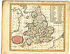
“England and Wales from the best Authorities" published as the act by Brightly & Kinnersley Bungay, February 10th, 1807. In upper corner references to the Counties. Copper engraved map with contemporary outline hand color.
Engraved by J. Barlow.
CONDITION: Good condition.
MEASUREMENTS: Size 10 ¼ x 8 1/8 inches
ALL OUR ARTIFACTS ARE ACCOMPANIED BY A CERTIFICATION OF AUTHENTICITY
WE SHIP INTERNATIONALLY
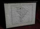
Map of the South American continent, titled "Amerique Meridionale", by Felix Delamarche, 1822. The map is on old type laid paper, and measures 12 3/4" by 16 3/4". There is a distinct plate mark and a central fold. The borders of Brazil, Peru, Chile, Patagonia and French Guyana are colored in green, yellow and blue. I do not know if the map is laid down, not having opened it up, but would be happy to do so upon request. There are seven separate dark stains, all except for one in the margins,...
For the collector of Victoriana or autographs of noted writers, here is an authentic signature of the English 19th century novelist and satirist WILLIAM MAKEPEACE THACKERAY (1811-1863), found on what appears to be a library slip. The writing on the slip refers to the borrowing of the book "Histoire de la Reine Zarah et les Zarasiens", 1712. This little piece of history gives some indication of the reading habits of the famous author. Condition of the slip is typical of what would be expected...
Antique small map titled "The World as known to Ptolemy", 1835, published by Joseph Thomas, London. The measurements are 5" by 6" inside the tasteful maroon map (10 1/4" by 11 1/4" framed). There is hand coloring in red outlining most of Europe. The map is very clean. Mat at lower extreme right has a bit of puckering/creasing. You could replace if so desire but most viewers would not notice this. Ptolemy was a Greco-Egyptian astronomer, geographer and mathematician who lived in Alexandria,...
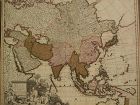
Fine antique copper engraving map of Asia from the eastern Mediterranean to the western Pacific, with hand coloring, by Dutch cartographers Gerardo and Leonardo Valk, circa 1710. The map measures 20" by 24" and is laid down to a board as is often seen. Margins are adequate. The map is I believe in overall good condition for a collector looking for a display item, though there are condition issues to be noted, such as some foxing, discoloration, margin wear, stubbed corner, a slight abraded ar...
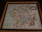
This is a very detailed map of Worcestershire in western England, first engraved by noted London map maker Robert Morden in 1695 for Camden's Britannia, and issued in several later editions in the early years of the 18th century. The map measures 14 1/4" by 16 5/8" inside the mat (17" by 19" as framed). Like most of its type it has been hand colored at a later date. The condition is good, with fresh excellent color, minimal oxidation, and some light handling creases at lower left and upper ri...
Antique French 18th century map of the Mediterranean Sea regions and the Holy Land, titled "Carte des Regions et des Lieux....Nouveaux Testament", by noted French cartographer Rigobert Bonne (1727-1794), published Paris circa 1771. Measurements inside the mat 12 1/4" by 17 3/4" (21" by 25" as framed). Bonne was one of the premier cartographers of his day, having gained a reputation for producing accurate and practical maps. He succeeded the well-known Jacques-Nicolas Bellin as Royal Cartograp...
A copper engraved print from The Modern Universal British Traveler published around 1779. It is hand colored and matted.
Condition is fine to very fine. A plastic sleeve protects the print.
Dimensions (matted, inches)
Height: 11 1/2
Width: 15
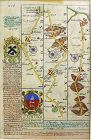
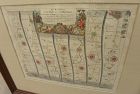
John Owen and Emanuel Bowen created innovative road maps in the early 18th C greatly aiding travelers of the day, whose publication spanned 1720-1764, titled Britannia Depicta.
This map is from pages 207/208, double-sided, and whose primary view is of Lincoln / Grimsby. The map features a coat of arms and covers Lincoln, Market Rasen and Grimsby.
This hand colored example is matted and believed to be in fine or very fine condition.
Dimensions (matted, inche...
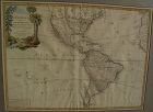
Very nicely presented, wall-ready antique map centered on the Americas, 1784, by Paris-based late 18th century cartographer Jean Janvier. The map, 19" by 25 3/4"inside the mat and 30 3/4" by 36 3/4" in new black ornate frame, is generally in fresh, clean condition, with center fold and some unevenness of the paper, which photographs as shadows or brown areas. The map features an interesting cartouche at upper left, including a beaver dam along a stream, which is bordered by palm trees on one s...
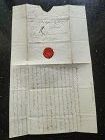
A very rare Original Letter written in black ink and bearing the Seal of the late Duchess of Richelieu (France) to Monsieur de Sinner, Berne, Switzerland, DATED 1797.
Size open letter: 18 cm. x 15 cm.
French Transcript available upon request.
Price: US$ 475
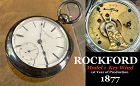
ROCKFORD WATCH CO.
Rockford, Illinois
1873 – 1915
The Rockford Watch Company’s equipment was bought from the Cornell Watch Col, and two of Cornell’s employees, C.W. Parker and P.H. Wheeler, went to work for Rockford. The factory was located 93 miles from Chicago on the Rock Rover. The first watch was placed on the market on May1, 1878. They were key wind, 18 size, full plate expansion balance and dials made by outside contract. By 1877 the company was making ¾ plate and nickel move...
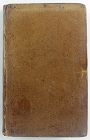
Hardcover. Condition: Good. 2nd Edition. Bound in polished leather, printed on laid paper, gilt tooling on spine, all leather spine labels intact, all covers attached, binding and hinges secure. Previous ownership: armorial bookplate for Thomas Taylor, County Devon parish Denbury. Cover fans out, cracking and minor losses of leather at the spine hinges, generally, though not perfectly, bright and clean pages.
Dimensions
Height: 7 1/2 inches
Width: 4 3/4 inches
T...
A very nice example of the 1753 map "The Smaller Islands in the British Ocean", published by T. Bowles, London, engraved by Emmanuel Owen, text by John Owen, the map featuring the Isle of Wight, Scilly Islands in the far southwest, the Channel Islands of Guernsey, Jersey, and Alderney, as well as Farne Island and Holy Island. At top is given the mile marker landmarks on the road from London to Southampton. Beautiful unusually good quality hand-coloring and condition is excellent. Nicely frame...
An original copper plate engraved map, with hand coloring of country outlines, and also in the cartouche, titled there, at lower left, "A Map of Turky, Arabia and Persia", the first edition by Georges de l'Isle in 1701, this being the somewhat later revised 1721 edition by noted cartographer of the day John Senex (1678-ca. 1740). This map, 19" by 23" (22 1/2" by 26 1/2" as framed) was considered to be the first modern map of the Arabian Peninsula before the middle of the 18th century. The geog...
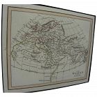
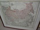
Original map printed in the year 1739 in Nuremberg, Germany, titled in cartouche at upper left "Imperii Russici et Tartariae Universiae", published by the heirs of important cartographer Johann Baptiste Homanns. The attractive map shows most of Asia from the Baltic Sea to the Pacific Ocean, and from the Arctic Ocean to India, including the Korean peninsula, Japan, and Taiwan. The map measures 20" by 22 1/2" inside the mat and 25 1/2" by 28" as framed. Condition is excellent. I see at least o...
This is a miniature map, 3 3/8" by 4 7/8" inside the mat, titled at upper right "EUROPA", and bearing at lower right the name of the engraver cartographer, Pieter van den Keere (Petrus Kaerius). The entire sweep of Europe is shown, from Greenland and Atlantic islands on the west to as far east as Turkey, the Middle East, and "Tartaria". Kaerius (circa 1571-1646) was born in the Low Countries and fled to London due to religious persecution, in 1584. There he became established in engraving map...
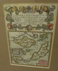
Rare antique Map of Alderney c1691 by Robert Morden with watercolor . Small scale map in nice condition framed and matted c19303s. Overall 9.75 by 6.5" map 5.25" by 3"
Early map titled "A Description of the Land of Goshen and Moses passage through the desert", 1614, by the English cartographer William Hole. Hole was active in cartography from about 1601 to about 1624. The map measures 10 3/4" by 14" inside the present mats (not examined out of the frame but would be happy to do so upon request). This is an uncommon map with a compass rose at lower right and cartouches at upper portion, the cartographer's name at lower left edge. There is probably much late...
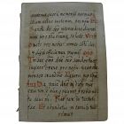
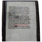
A miniature size hand written in Latin manuscript page, double sided, measuring 4 1/4" by 3", and 8 1/2" by 6 1/2" nicely framed, likely of religious content. Written neatly in brown ink with red capitals in places, much as would be seen in an antiphonal sheet. Condition of this little item, a survivor at many hundreds of years old, is excellent.
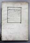
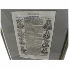
A very rare and complete antique license document, Spanish and signed by the Spanish King Philip the IV (Ruler 1621-1665).
The document is binded with 8/16 pages with 14 decorated or with signatures (let us know if you like to receive pictures of all pages by e-mail). We would like to stress the importance of the document which signed by no less than 15-20 signatures, besides the signature of Philip himself. These co-signers could well be important members of his cabinet or high leve...
An example of an original 17th century copper engraving map with later hand coloring, titled "The Road from Oxford to Cambridge", from the first road atlas of England and Wales, by noted mapmaker JOHN OGILBY (1600-1676). The piece measures 14 1/2" by 17 1/2" inside the mat, 26 1/2" by 28 1/2" as framed. Ogilby's "Britannia" atlas was truly ground-breaking in its time, as it was the first survey of roads in the British Isles and marked the first use of the so-called "Waywiser", a wheeled device...
Antique early map of central England's Oxfordshire county, by cartographer Robert Morden, originally published in 1695. This map is nicely hand colored. It measures 17" by 15" inside the green mat and 24" by 22" framed (no glass). The mat was seemingly permanently affixed over the margins of the map by the framer, but the central portion of the map does not appear to be laid down as there is play to the surface. There is central horizontal crease and slight handling creases in the field. No...
An page from a fifteenth century "Book of Hours", DOUBLE SIDED, page 6 3/4" by 4 3/4, framed with glass on both sides to facilitate viewing. There are 16 lines of text in Latin, decorative borders and capitals with extensive use of gold. According to Wikipedia, books of hours were Christian devotional books popular in the Middle Ages. They are considered the most common type of surviving medieval illustrated manuscripts. Generally they contained prayers and psalms. As the fifteenth century wore...
The Nuremberg Chronicles is considered a landmark work in the history of the printed book, and an example of incunabulum (book printed before the year 1500). Described in Wikipedia as essentially a biblical paraphrase, and a history of the known world to that date, it is one of the most extensively illustrated books of the 15th century, considered one of the first to successfully integrate illustrations and text. Printed on high quality rag paper that has survived the centuries, in both Latin an...
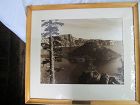
A large sepia toned silver print of Wizard Island in Crater Lake in a textured white mat, a simple light wood frame and a brass plaque inscribed, “CRATER LAKE – WIZARD ISLAND/ CRATER LAKE NATIONAL PARK.” No signature on the face of the photo and it has not been removed from what was probably the original frame and mat. Sight size image 15 X 19 inches. Frame 23 X 25 ¾ inches.,p.
Condition: photo in excellent condition, probably glued down to the backing board. Frame with lots of small ...
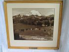
A sepia toned silver print of Tipsco lake with Mount Rainer in the background in a textured white mat, simple blond wood frame and a brass plaque identifying the image as follows, “MT. RAINER – TIPSCO LAKE/ MT. RAINER NATIONAL PARK.” Out of the frame there is no identification of the photographer. Image 15 3/8 X 19 3/8 inches. Frame 23 X 25 7/8 inches.
Condition: examined out of the frame. The photograph is laid down on the backboard, but otherwise in excellent condition. Frame with nu...
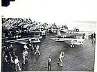
This is an original official WWII photo of fighter planes on the USS Bunker Hill set for take-off for the first attack on Rabaul, November 11, 1943; condition: very good; measurement: 8 x 10 in.
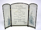
A rare piece of ephemera, this standing Wedding Dinner Menu from 1915 gives us a glimpse into food and style from the past. Comprised of a thin nylon type fabric fitted inside a metal three panel screen, the front "doors" are hand painted with clumps of lavender iris, opening to a larger centered panel printed with the menu reading: Wedding Dinner of Mr. and Mrs. Samuel Alexander, Menu, Grape Fruit Cocktail, Consomme Vemicelli and Marrow Balls, Kennebec Salmon Sauce Mayonaise, Parsley Potatoes, ...
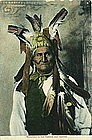
"Geronimo in His Famous War Bonnet"
Rare postmark from around the time of his captivity: "Chickasha OKLA Feb 13 1908".
Slight paper loss around the edges.
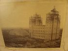
This is a James William Shipler early historical photograph of the laying of the capstone of the Salt Lake City Mormon Temple, April 1892. The image area measures 6 1/2" by 9" and the entire piece with likely original turn of the century Victorian style frame is 14 1/2" by 16 1/2". Shipler (1849 - 1937), left McKeesport, Pennsylvania in 1887, seeking adventure in the great west. He opened studios in Denver and Great Falls, Montana before arriving on the scene in Salt Lake City. In 1890, he o...
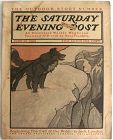
Long before Norman Rockwell became a legend at The Saturday Evening Post, this Curtis Publishing Company juggernaut established itself is a publisher of leading and future literary figures, not the least of whom was Jack London. The magazine struck a gold vein when it published the little known Jack London whose Call of the Wild novel would become a fixture on high school and college reading lists for decades to come. The American classic first appeared on the page of SEP before it become a mons...
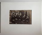
An albumen photograph of five women, with knitting, seated on the ground and two girls standing behind them against a stone wall or side of a cottage. George Washington Wilson (Scottish, 1823-1893) was already a successful photographer with a large business in Aberdeen when he made a photographic journey to the Outer Hebrides in 1885. This photograph is titled in the bottom center of the negative, “Maids and Matrons St. Kilda.” with the number 6196 and the photographers initials G.W.W. Ima...
Albumen photograph of two Bedouin musicians seated in front of a backdrop with their string instruments. Numbered 613 and titled “Joueurs de violon Bedouins” in white in the negative and signed, “Bonfils.” The image is 8 ¾ x 11 inches (22.5 x 28 cm) mounted on card 11 x 13 ½ inches (28 x 34 ½ cm).
Condition; photo in good condition, though the contrast could be a little stronger. Mount discolored, some foxing and soiled along some edges.
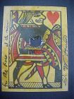
A Jack of Hearts playing card shot through the heart, signed J.W. Hardin in the bottom right hand margin and for Mr. Ford in the bottom left hand margin along with 3 words I cannot read. The handful of other known examples, estimated to be between 6-17 appear to be from the same deck. The gunslinger was part owner of the bar and gambling venue and he reportedly signed these cards for patrons as a souvenir of a shooting demonstration he put on for the Fourth of July. John Wesley Hardin (1853-1895...
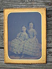
The image is almost certainly a tinted salt print mounted between two pieces of glass and matted to appear similar to a daguerreotype. Most of the original paper seal is still on the glass, but where it is missing the edge of a piece of paper is visible between the pieces of glass. It is translucent when held to a strong light. Overall 6 ¾ inches by 8 ½ inches.
Condition: there are a few light spots under the glass where presumably the paper and the glass are not touching, but otherwise th...
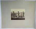
Albumen of three large columns and a couple of men in front of a large forum (?) with Mount Vesuvius in the distance mounted on grey stock. Excellent tones and sharp image. 7 38 inches tall and 9 ¼ inches wide (18.5 x 23.5 cm). Sheet 18 by 22 inches (46 x 56 cm).
Condition; excellent with minor surface scuffing to the image. Card with some spots, rough edges and rounded corners, but overall clean.
A very good quality image, found with a group of other Italian architectural images mou...